
Elevation 275 m | ||
 | ||
Similar Mount Azuma‑kofuji, Mt Ryozen, Mount Adatara, Mt Issaikyo, Senganmori | ||
4k
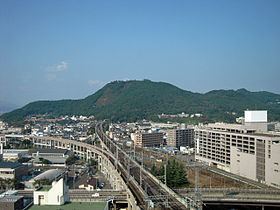
Mt. Shinobu (信夫山, Shinobu-yama) is a 275-meter monadnock located in the center of Fukushima, Fukushima, Japan.
Contents
- 4k
- Map of Mount Shinobu Hayama Oyama Fukushima shi Fukushima ken 960 8252 Japan
- Epilogue the view from the mount shinobu yama a77 movie
- Geography
- References
Map of Mount Shinobu, Hayama Oyama, Fukushima-shi, Fukushima-ken 960-8252, Japan
Epilogue the view from the mount shinobu yama a77 movie
Geography
Mt. Shinobu rises 275 meters from the surrounding flat Fukushima Basin. The mountain has three main peaks: Mt. Ha (羽山, Ha-yama) is on the western part of the mountain and is the tallest peak at 275 meters, Mt. Haguro (羽黒山, Haguro-san) is in the center and tops out at 260 meters, and Mt. Kumano (熊野山, Kumano-san) is a 268-meter peak in the east. In addition to the three main peaks, there are also the smaller peaks of Mt. Tatsuishi (立石山, Tatsuishi-yama), which is north of Mt. Kumano and stands at 220 meters, and Tengunomori (天狗の森), which is a 183-meter peak on the southeast of the mountain.
Mt. Shinobu is 2.7 km long from east to west, 1.4 km wide from south to north, and has a circumference of seven kilometers.