
Elevation 2,858 m Prominence 749 m | First ascent 1926 Mountain range Lewis Range | |
 | ||
Similar Mount Stimson, Mount Rockwell, Blackfoot Mountain, Mount Logan, Mount Jackson | ||
Mount saint nicholas glacier park 9 20 2014
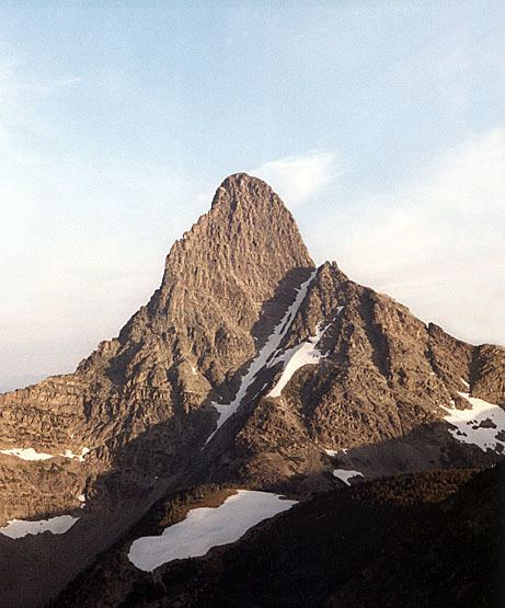
Mount Saint Nicholas is a peak in the remote southwestern section of Glacier National Park, in Montana, United States. It is a particularly steep, pointed rock pinnacle, and its distinctive profile is visible from many summits in the southern half of the park. Because even its easiest ascent route is technical, with poor rock quality, it is "considered the most dangerous and difficult mountain for climbers in Glacier National Park."
Contents
Map of Mt St Nicholas, Montana 59936, USA
Mount Saint Nicholas excels in terms of steep vertical relief, even by the high standards prevalent in Glacier National Park. For example, its northwest face rises one vertical mile (5,280 ft/1,609 m) in approximately 1.5 horizontal miles (7,920 ft/2.4 km). Due to its pointed shape and isolation from the Continental Divide, it has similarly precipitous drops in all directions.
In 1926, Reverend Conrad Wellen, of Havre, Montana, made the first ascent of Mount Saint Nicholas. This was a significant achievement, since the mountain had been considered by many to be unclimbable. The standard route is the Northeast Ridge. Starting from the east side of the peak, this route begins with a straightforward scramble up a gully to a prominent notch. From the notch a thousand vertical feet of somewhat technical climbing remain.