
Elevation 1,752 m | ||
 | ||
Similar Mount Wuteve, Mont Tonkoui, Mount Bintumani, Mount Loura, Mount Tenakourou | ||
Mount Richard-Molard is a mountain along the border of Côte d'Ivoire and Guinea in West Africa. The highest peak for both countries and the Nimba Range is at 1,752 m (5,750 ft). The mountain is a part of the Guinea Highlands, which straddles the borders between the two countries, Sierra Leone and Liberia. The nearest major settlements are the town Yekepa to the west in Liberia and N'Zoo in Guinea.
Contents
Map of Mount Richard-Molard
Toponymy
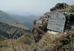
The mountain is named after the French geographer Jacques Richard-Molard, who died in an accident at the mountain site in 1951. Before that it was called Mount Nouon.
Geology
The mountain is rich in iron ore and cobalt. The mix of iron-quartzite sheets, schists and granitogneiss has produced startling land formations by soil erosion.
Conservation
Mount Richard-Molard lies within the Mount Nimba Strict Nature Reserve, which currently covers 17,540 hectares.
World Heritage status
This site was added to Guinea's "Tentative List" for consideration for UNESCO World Heritage Site status on 29 March 2001 in the cultural category.
Mount Nimba Strict Nature Reserve has been listed as a World Heritage Site in both Guinea and Côte d'Ivoire under the criteria for natural heritage.