
Elevation 4,150 m Prominence 410 m | First ascent 1934 | |
 | ||
Mountain range Fairweather Range, Saint Elias Mountains Similar Mount Crillon, Mount Fairweather, Mount Alverstone, Mount Hubbard, Mount Sir Wilfrid Laurier | ||
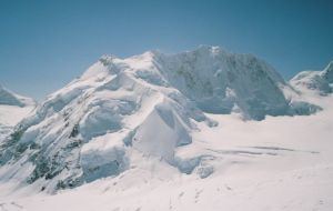
Mount Quincy Adams (alternate Name Boundary Peak 163) is a mountain located on the border between United States and Canada. It is named after John Quincy Adams (1767–1848), the sixth president of the United States.
Map of Mt Quincy Adams
The southern and eastern flanks of the mountain are in Glacier Bay National Park, in Hoonah-Angoon Census Area, Alaska. The northern and northwestern flanks are in Tatshenshini-Alsek Park, in Stikine Region, British Columbia, making it the second highest peak in B.C. Mount Quincy Adams is flanked to the west by Mount Fairweather 4,671 m (15,325 ft).
References
Mount Quincy Adams (Fairweather Range) Wikipedia(Text) CC BY-SA