
Topo map Mallardy Ridge Prominence 872 m First ascender Louis C. Fletcher | Elevation 1,628 m Parent range Cascade Range | |
 | ||
Similar Three Fingers, Mount Dickerman, Vesper Peak, Whitehorse Mountain, Mount Pugh | ||
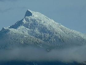
Mount Pilchuck is a mountain located in Snohomish County, Washington. It is 57 miles (92 km) northeast of Seattle. It is part of the Cascade Range.
Map of Mt Pilchuck, Washington 98252, USA
Mount Pilchuck is located within Mount Pilchuck State Park, but the area surrounding the mountain, including the trailhead, are within the Mount Baker-Snoqualmie National Forest. The Lushootseed name for the mountain is bəlalgʷa. Under agreement, the trail leading to the summit is wholly maintained by the United States Forest Service, even though it is within a state park. This is one of the most popular trails in the region due to easy access, and panoramic views of the Cascade range to the east, and the Puget Sound to the west.
At Mount Pilchuck's summit is an old fire lookout, now used as shelter for hikers. This former lookout is jointly maintained by Washington State Parks and the Everett branch of The Mountaineers.
Some years the trail to the summit is still covered with snow until late in the summer.