
Parent range Explorer Range | Elevation 1,094 m | |
 | ||
Similar Blue Mountains, Mount York, Mount Trickett, Mount Boyce, Mount Bindo | ||
Flake crack 17 mount piddington a father son expedition
Mount Piddington (Aboriginal: Wirindi), a mountain in the Explorer Range of the Blue Mountains region, is located south of the village of Mount Victoria in New South Wales, Australia.
Contents
- Flake crack 17 mount piddington a father son expedition
- Map of Mount Piddington Mount Victoria NSW 2786 Australia
- References
Map of Mount Piddington, Mount Victoria NSW 2786, Australia
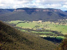
The mountain has a lookout, restrooms and a picnic area at its summit, surrounded by a loop road, Mount Piddington Road, which runs from the summit to Mount Victoria village. It is also the starting point of several bushwalking tracks that descend to the cliffs of Hornes Point and the Fairy Bower reserve. Notable sites on the slopes of Mount Piddington include Coxs Leap and Bushranger Cave.
Views of the Kanimbla Valley are possible from the lookout, although trees are present and it is not entirely clear. The mountain is mostly covered in bushland of the Eucalypt variety and adjoins One Tree Hill, the highest point in the Blue Mountains Plateau, though Mount Werong is the overall highest peak of the Great Dividing Range.