
Parent range Omoto Range | Elevation 526 m | |
 | ||
Similar Mount Yonaha, Mt Komi, Yarabudake, Karadake, Katsuudake | ||
Mount omoto
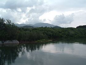
Mount Omoto (於茂登岳, Omoto-dake) is a mountain located on Ishigaki Island in Okinawa, Japan. Together with Kabira Bay it is a nationally designated Place of Scenic Beauty.
Contents
- Mount omoto
- Map of Mount Omoto Tonoshiro Ishigaki Okinawa Prefecture 907 0004 Japan
- Overview
- References
Map of Mount Omoto, Tonoshiro, Ishigaki, Okinawa Prefecture 907-0004, Japan
Overview
At 525.5 metres (1,724 ft) above sea level, Mount Omoto is the tallest mountain in Okinawa Prefecture. It is located on the island of Ishigaki, near the center of the Omoto Mountain Range, which runs east to west along the northern coast of the island.
Geologically, it is formed by granite from the Neogene Period. The Miyara River flowing from the northeast side and the Nagura River flowing from the south side of the mountain are vital sources of drinking and agricultural water on the island.
References
Mount Omoto Wikipedia(Text) CC BY-SA