
Population 55 (2006 census) Postcode(s) 4871 Founded 1910 Postal code 4871 | Established 1910 Local time Monday 2:16 PM | |
 | ||
Location 1,869 km (1,161 mi) NW of Brisbane214 km (133 mi) W of Cairns143 km (89 mi) W of Mossman LGA(s) Tablelands Regional Council Weather 32°C, Wind NE at 11 km/h, 59% Humidity | ||
Mount Mulligan is a former mining town and rural locality in northern Queensland, Australia, the site of Queensland's worst mining disaster.
Contents
Map of Mount Mulligan QLD 4871, Australia
A railway connected Mount Mulligan with Dimbulah on the Chillagoe Railway. It opened on 7 April 1915 and was officially closed in January, 1958.
History
It was a coal mining town from 1910 until 19 September 1921 when an underground explosion killed 75 miners (all the miners in the town). The mine closed, but reopened in 1923 and continued in production until 1957 when a hydro-electric scheme eliminated the need for the coal.
The town's coal was mined from shafts dug into a Permian layer within the cliff face or escarpment of a large 18 kilometres (11 mi) x 6.5 kilometres (4.0 mi) free-standing conglomerate and sandstone massif (rising up to 400 metres above the township) known by the name given it by the small group of prospectors who first sighted it in 1874 while searching the Hodgkinson River for gold, under the leadership of James Venture Mulligan.
The conglomerate and sandstone massif known to local Djungan aboriginal peoples as Ngarrabullgan was given James Mulligan's surname. The name Mount Mulligan was later given to the township that grew in the shadows of the massif's escarpment.
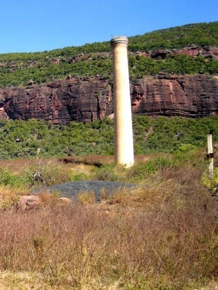
The area of the township itself remains gazetted as a township, but is now a ghost town, with a single cemetery, a single occupied residence, a single chimney stack, and the overgrown remains of the once busy mining operations and electricity generator. At the 2006 census, Mount Mulligan and the surrounding area had a population of 55.
Mount Mulligan Post Office opened by July 1914 (a receiving office had been open from 1907) and closed in 1959. A Mount Mulligan RailPost Office was open between 1916 and 1920.
Nearby towns are Julatten, Dimbulah, Mount Carbine and Mount Molloy.