
Location Palawan Region MIMAROPA Elevation 2,085 m Province Palawan Listing Ultra-prominent peak | Country Philippines Parent range Mantalingahan Range Prominence 2,085 m Municipality Brooke's Point | |
 | ||
Similar Mount Guiting‑Guiting, Thumb Peak, Mount Halcon, Mount Victoria - Palawan, Mount Dulang‑dulang | ||
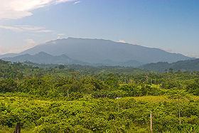
Mount Mantalingajan (or Mantalingahan or Mantaling) is a mountain in southern Palawan, Philippines, that forms the highest part of the Mount Beaufort Ultramafics geological region, a series of ultramafic outcrops of Eocene origin, of which Mount Victoria forms the largest contiguous land area. The peak of the mountain is the highest point on Palawan.
Contents
Map of Mount Mantalingajan, Rizal, Palawan, Philippines
The mountain forms the center of the Mt. Mantalingahan Protected Landscape (MMPL), a national park covering the entire Mantalingahan Mountain Range. The protected area status of MMPL was proclaimed last June 23, 2009, by virtue of Proclamation No. 1815 by President Gloria Macapagal-Arroyo. The protected area covers an area of 120,457 hectares.
Continuing discoveries of new species of plant and animal from the mountain highlight its tremendous ecological value and the importance of maintaining such protective zones in the face of constant logging and mining pressures. The pitcher plant species, Nepenthes mantalingajanensis, described in 2007, is named after the mountain itself.
Hiking activityEdit
Mt. Mantalingajan is one of the most difficult climbs in the Philippines, being graded Difficulty 9/9 by local mountaineering website PinoyMountaineer.com. The usual route starts from Barangay Ransang in Rizal on the south-west coast of Palawan. Three days hiking is required to reach the summit and two days to return to the jump-off, a total of five days, unless another day is wanted exploring the summit and surrounds. Highlights of the trail include encounters with the Tau't Bato tribe and the "Knife Edge" Canopy Walk that leads to the summit.