
Translation black peak (Japanese) Mountain type lava dome Elevation 1,984 m | Location Hokkaidō, Japan Volcanic arc/belt Kurile arc Easiest route Hiking | |
 | ||
Topo map Geographical Survey Institute 25000:1 層雲峡
50000:1 大雪山 Mountain range Daisetsuzan Volcanic Group Parent range Daisetsuzan Volcanic Group Similar Mount Eboshi, Mount Hokuchin, Mount Hakuun, Asahi‑dake, Mount Chūbetsu | ||
Sounkyou kurodake ropeway daisetsuzan national park hokkaido time lapse
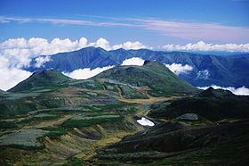
Mount Kuro (黒岳, Kuro-dake) is a lava dome located in the Daisetsuzan Volcanic Group of the Ishikari Mountains, Hokkaidō, Japan.
Contents
- Sounkyou kurodake ropeway daisetsuzan national park hokkaido time lapse
- Map of Mt Kurodake Sounkyo Kamikawa Kamikawa District Hokkaido Prefecture 078 1701 Japan
- Climbing route
- References
Map of Mt. Kurodake, Sounkyo, Kamikawa, Kamikawa District, Hokkaido Prefecture 078-1701, Japan
Climbing route
The easiest way up the mountain is to use the Daisetsuzan Sōunkyō Kurodake Ropeway up from Sōunkyō. This takes you approximately 600 metres (2,000 ft) up the mountain. You can then use a chairlift to carry you up past the 1,500 metres (4,900 ft) mark. From there it is a hike with switchbacks the rest of the way to the top. You can also hike the entire route parallel to the ropeway and chairlift from Sōunkyō Onsen. A popular route continues past Mount Kuro, around the Ohachi-Daira caldera, over Mount Asahi and down the Asahidake Ropeway to Asahidake Onsen.
References
Mount Kuro Wikipedia(Text) CC BY-SA