
Topo map USGS Adak C-4 Volcanic arc/belt Aleutian Arc Last eruption 1995 Parent range Aleutian Range | Mountain type Stratovolcano Elevation 1,307 m Mountain range Aleutian Range | |
 | ||
Location Kanaga Island, Alaska, U.S. Similar Mount Akutan, Mount Adagdak, Tanaga, Korovin Volcano, Makushin Volcano | ||
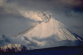
Mount Kanaga is a stratovolcano at the northern tip of Kanaga Island in the Aleutian Islands, Alaska. It is situated within a caldera, which forms the arcuate Kanaton Ridge south and east of Kanaga. A crater lake occupies part of the SE caldera floor. The summit of Kanaga has a crater with fumarolic activity.
Map of Mount Kanaga, Alaska, USA
It is located about 25 km (16 mi) west of the U.S. Navy installation and port on Adak Island. The volcano erupted intermittently through much of 1994, dusting the community of Adak at least once with fine ash.
References
Mount Kanaga Wikipedia(Text) CC BY-SA