
Elevation 901 m Mountain range Aleutian Range | Volcanic arc/belt Aleutian Arc Last eruption 1650 BC Parent range Aleutian Range | |
 | ||
Similar Mount Kukak, Fourpeaked Mountain, Mount Mageik, Ugashik‑Peulik, Pavlof Sister | ||
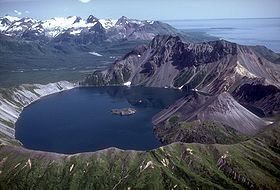
Mount Kaguyak is a stratovolcano located in the northeastern part of the Katmai National Park in Alaska. The 2.5 km wide caldera is filled by a more than 180 m deep crater lake. The surface of the crater lake lies about 550 m below the rim of the caldera. Postcaldera lava domes form a prominent peninsula in the center of the lake. The volcano is 901 m high and hosts a spectacular view because it rises from lowland areas near sea level in the south of the Big River. Based on radiocarbon dating the caldera-forming eruption occurred about 5800 years before present. During this eruption at least 120 square kilometers were covered in a dacitic ignimbrite.
Map of Mount Kaguyak, Alaska, USA
References
Mount Kaguyak Wikipedia(Text) CC BY-SA