
Elevation 3,184 m Prominence 2,187 m | First ascent 1964 Listing Ultra-prominent peak | |
 | ||
Similar Mount Kirkpatrick, Mount Paget, Mount Tyree, Mount Terror, Peter I Island | ||
Mount Jackson (Mount Andrew Jackson and Mount Ernest Gruening) is a mountain that dominates the upland of the southern part of the Antarctic Peninsula. It is located in Palmer Land, within the Antarctic claims of Argentina, Chile and the United Kingdom. With an elevation of 3,184 metres (10,446 ft), Mount Jackson is the highest mountain in the Antarctic Peninsula and the British Antarctic Territory. Discovered by members of the United States Antarctic Service, 1939–41, it was named for Andrew Jackson, the seventh President of the United States. The first ascent of Mount Jackson was made by a team led by John Crabbe Cunningham of the British Antarctic Survey (BAS) in 1964. Mount Jackson's geology was studied in 1972 as part of the Palmer Island investigations by a team of geologists.
Contents
Map of Mount Jackson, Antarctica
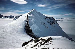
Mount Jackson and the Welch Mountains demarcate the central Black Coast, which is dissected by many inlets and is bounded on the west by Dyer Plateau of central Palmer Land. The two mountains rise above the ice shelf with reliefs of about 1,200–1,500 metres (3,900–4,900 ft) towards the east. They are interconnected by icefall zones forming a plateau with steep snow slopes. Mount Jackson rises from its southeast flanks, displaying a steeple summit, while the north flank is occupied by a vast cirque. Supraglacial moraines on the mountain's east side measure between 1–5 kilometres (0.62–3.11 mi) in length and display boulders at their distal ends.
History
The first topographic mapping of Mount Jackson was carried out in November 1940 by a sledge party of the United States Antarctic Service (USAS). The ground survey was facilitated by aerial photographs and aerial observations. The height was estimated at 4,200 metres (13,800 ft), and the mountain was named Mount Ernest Gruening after the Governor of the Alaska Territory at that time, Ernest Gruening. USAS later renamed it Mount Jackson for the seventh President of the United States. President Jackson signed the bill into law authorizing the United States Exploring Expedition of 1838–42. The expedition, led by Lt. Charles Wilkes, included exploration and surveying of the Pacific Ocean and surrounding lands, including Antarctica.
In November 1947, a Falkland Islands Dependencies Survey (FIDS) ground party based at Stonington Island observed Mount Jackson and estimated its height at 3,050 metres (10,010 ft), considerably lower and more accurate than the first estimate in 1940.
After the Falkland Islands Dependencies Survey was renamed British Antarctic Survey in 1962, a series of depots were developed, including one at Mount Jackson. BAS members were successful in making many first ascents of the mountains of the Antarctic Peninsula, and John Cunningham, who served at the BAS base at Adelaide Island, was the first to climb Mount Jackson. Traveling by dog sled for 640 kilometres (400 mi), his team reached the summit on 23 November 1964.
A precise height of the summit was determined by a BAS survey party who ascended the peak during the austral summer of 1996–97.
Geography
The mountain is 3,184 metres (10,446 ft) in height, with a prominence of 2,187 metres (7,175 ft) and a saddle DEM of 997 metres (3,271 ft). Mount Jackson and the Welch Mountains demarcate the central Black Coast, which is dissected by many inlets and is bounded on the west by Dyer Plateau of central Palmer Land, with elevation ranging between 2,000–3,000 metres (6,600–9,800 ft), and on the west side of the central Black Coast. The two mountains rise above the ice shelf with reliefs of about 1,200–1,500 metres (3,900–4,900 ft) towards the east. They are interconnected by icefall zones forming a plateau with steep snow slopes. The northern part of the mountain system, which extends over 1,590 kilometres (990 mi), covers most of the Antarctic Peninsula, and Mount Jackson is its highest peak.
Mount Jackson rises from its southeast flanks, displaying a steeple summit, while the north flank is occupied by a vast cirque. Supraglacial moraines on the mountain's east side measure between 1–5 kilometres (0.62–3.11 mi) in length and display boulders at their distal ends. Mount Jackson and the Rowley Massif are separated by Odom Inlet. Cline Glacier drains eastern Mount Jackson before arriving at Odom Inlet.
Mount Jackson's geology was studied in 1972 as part of the Palmer Island investigations by a team of geologists. They identified various rock types and underlying volcanic activity. The relief of the west facing slopes is gentler when compared to the eastern side, characterized by a steep rocky face. Rock weathering is intense in the area spread with scree and felsenmeer. Fresh rock formations and bedrock disintegration are noted.