
 | ||
Similar Pico Viejo, Teide, Roque de los Muchachos, Pico de las Nieves, Peñas del Chache | ||
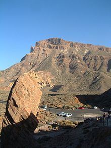
Mount Guajara is a 2718 m high mountain on Tenerife, in the Canary Islands.
Contents
Map of Mount Guajara, 38300, Santa Cruz de Tenerife, Spain
Mount Guajara along with the entire Island of Tenerife is an extinct volcano which has a large crater close to its summit which is accessible by road, the last leg to the summit at the northern end which is its highest point can be reached from a trail head within the crater,there is also an astronomical observatory located along a ridge at the southern end of the crater, by way of topographic prominence the mountain contends along with some of the worlds highest peaks.
Climbing routes
There are several different routes from the north and from the south. For the north access the most convenient starting point is at the hotel Parador. You have nice roads to the Parador from four different sides of the island, and there is bus service both from the north and from the south. You will need up to two hours from the hotel to the summit.
One convenient starting point from the south is at the Vilaflor village and you will need at least 4 to 5 hours to the summit. This is a considerably more difficult route due to the lower starting point which is at around 1400 meters above the sea level.
There are no restrictions or permits for climbing Guajara.