
Elevation 190 m | ||
 | ||
Similar Blue Lake, Mount Schank, The Blue Lake, Piccaninnie Ponds Conserva, Cave Gardens | ||
Mount gambier volcano top 8 facts
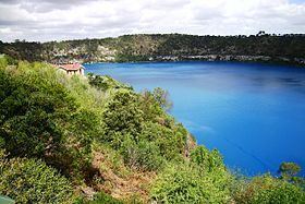
Mount Gambier (also known as Ereng Balam,meaning eagle hawk) is a maar complex in South Australia associated with the Newer Volcanics Province. It contains four lake-filled maars called Blue Lake, Valley Lake, Leg of Mutton Lake, and Brownes Lake. It is one of Australia's youngest volcanoes, but estimates of the age have ranged from over 28,000 to less than 4,300. The most recent estimate, based on radiocarbon dating of plant fibers in the main crater (Blue Lake) suggests an eruption a little before 6000 years ago.
Contents
Map of Mount Gambier, SA 5290, Australia
Mount Gambier is thought to have formed by a mantle plume centre called the East Australia hotspot which may currently lie offshore.
The mountain was sighted by Lieutenant James Grant on 3 December 1800 from the survey brig HMS Lady Nelson and named for Lord James Gambier, Admiral of the Fleet.
This area is part of the UNESCO-endorsed Kanawinka Geopark.
Of the original four lakes found within the maars, only two remain. The Leg of Mutton Lake (named for the outline of its shoreline) became permanently dry in the 1990s. Brownes Lake suffered a similar fate during the late 1980s. Both these lakes were quite shallow; their demise is attributed to the lowering of the water table as a result of many years of land drainage to secure farmland.
The city of Mount Gambier partially surrounds the maar complex.