
Translation oratory (Irish) Topo map OSi Discovery 1 Prominence 688 m Mountain range Derryveagh Mountains Listing Marilyn | OSI/OSNI grid B928207 Elevation 751 m Province Ulster Parent range Derryveagh Mountains | |
 | ||
Similar Muckish, Slieve League, Mackoght, Slieve Snaght, Slieve Donard | ||
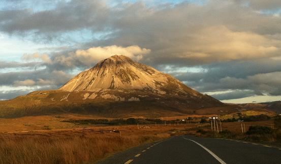
Errigal (Irish: An Earagail, possibly meaning "oratory") is a 751-metre (2,464 ft) mountain near Gweedore in County Donegal, Ireland. It is the tallest peak of the Derryveagh Mountains, the tallest peak in County Donegal, and the 76th tallest peak in Ireland. Errigal is also the most southern, steepest and highest of the mountain chain, called the "Seven Sisters" by locals. The Seven Sisters includes Muckish, Crocknalaragagh, Aghla Beg, Ardloughnabrackbaddy, Aghla More, Mackoght and Errigal. The nearest peak is Mackoght, which is also known as Little Errigal or Wee Errigal (Irish: an Earagail Bheag).
Contents
- Map of Errigal Mountain Money More Co Donegal Ireland
- Climbing ErrigalEdit
- In popular cultureEdit
- References
Map of Errigal Mountain, Money More, Co. Donegal, Ireland
Errigal is well known for the pinkish glow of its quartzite in the setting sun. Another noted quality is the ever-changing shape of the mountain depending on what direction you view it from. Errigal was voted 'Ireland's Most Iconic Mountain' by Walking & Hiking Ireland in 2009.
Climbing ErrigalEdit
The mountain is most often climbed from the carpark off the R251 road. The route initially starts off by crossing heavily eroded and boggy land towards a visible track through the shiny scree from where the ascent proper starts. After reaching the summit, people usually walk the short but exposed walk along ‘One Man’s Pass’ which leads across to the second and lower of the twin summits. No special equipment is needed to climb the mountain, but caution is advised.