
Isolation 1.29 mi (2.08 km) Prominence 143 m | Elevation 4,223 m | |
 | ||
Topo map USGS 7.5' topographic mapGrays Peak, Colorado Similar Argentine Peak, Grays Peak, Mount Guyot, Mount Parnassus, Engelmann Peak | ||
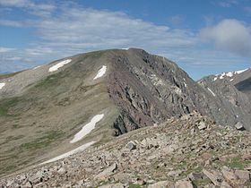
Mount Edwards is a high mountain summit in the Rocky Mountains' Front Range of North America. The 13,856-foot (4,223 m) thirteener is located in Arapaho National Forest, 7.6 miles (12.3 km) southwest (bearing 223°) of the Town of Georgetown, Colorado, United States, on the Continental Divide between Clear Creek and Summit counties.
Map of Mount Edwards, Colorado 80476, USA
References
Mount Edwards (Colorado) Wikipedia(Text) CC BY-SA