
Isolation 1.49 mi (2.40 km) Prominence 188 m Easiest route Hiking | Elevation 4,189 m | |
 | ||
Topo map USGS 7.5' topographic mapMontezuma, Colorado Similar Mount Edwards, Mount Parnassus, Engelmann Peak, Mount Guyot, Bard Peak | ||
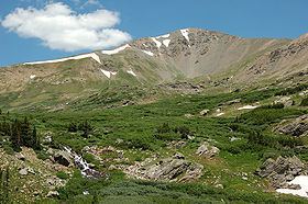
Argentine Peak is a high mountain summit in the Front Range of the Rocky Mountains of North America. The 13,743-foot (4,189 m) thirteener is located in Arapaho National Forest, 8.5 miles (13.6 km) southwest by south (bearing 211°) of Georgetown, Colorado, United States. The summit lies on the Continental Divide between Clear Creek and Summit counties.
Map of Argentine Peak, Colorado 80435, USA
The peak is approximately 1 mile south of Argentine Pass. The peak and the pass take their names from the Argentine District, Colorado's first major silver mining district. Argentum is the Latin word for silver, for the silver ore found in the area.
References
Argentine Peak Wikipedia(Text) CC BY-SA