
Topo map USGS Damnation Peak Prominence 564 m | Elevation 2,224 m | |
 | ||
Similar | ||
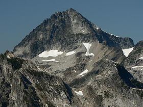
Mount Despair is a rugged mountain in the North Unit of North Cascades National Park in Washington state. Northeast of Mount Despair lies the Picket Range.
Contents
Map of Mt Despair, Washington 98283, USA
The mountain's name was given by Lage Wernstedt of the U.S. Forest Service who mapped the region in the 1920s. The name Mount Despair first appeared on Forest Service maps in 1931.
Nearby peaksEdit
References
Mount Despair (Washington) Wikipedia(Text) CC BY-SA