
Topo map NTS 82O/03 Prominence 348 m | Parent range Fisher Range Elevation 2,192 m Province Alberta | |
 | ||
Easiest route Easy scramble to North peak moderate to others. Similar Mount Lady Macdonald, Heart Mountain, Grotto Mountain, Mount Chester, Mount Lawrence Grassi | ||
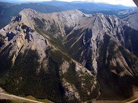
Mount Baldy is a mountain located in the Kananaskis River valley alongside Highway 40 in the Canadian Rockies.
Map of Mount Baldy, Kananaskis, AB, Canada
During World War II, prisoners in a nearby internment camp were occasionally permitted to make the ascent of Mt. Baldy as long as they promised to return. A University of Calgary research centre now occupies the former location of the camp.
Up until 1984, when it was given its current day official name, it was commonly referred to as Barrier Mountain, due to its proximity to Barrier Lake.
References
Mount Baldy (Alberta) Wikipedia(Text) CC BY-SA