
Elevation 1,795 m Parent range Arthur Range | Mountain range Arthur Range | |
 | ||
Similar Mount Owen, Mount Tapuaenuku, Mount Matthews, Mount Robert, Spenser Mountains | ||
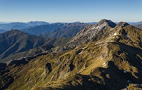
Mount Arthur (Tuao Wharepapa in Māori) is in the Arthur Range in the north western area of the South Island of New Zealand. Mount Arthur, named after Captain Arthur Wakefield, lies within Kahurangi National Park and has a peak elevation of 1,795 metres (5,889 ft).
Contents
Map of Mount Arthur, Kahurangi National Park 7073, New Zealand
Geology
Mt Arthur is made of hard, crystalline marble, transformed (hardened) from limestone, originally laid down under the sea some 450 million years ago. Below ground are some of the deepest shafts and most intricate cave systems in the country, and exploration of these is far from finished. Mount Arthur is home to the Ellis Basin cave system, the deepest cave in the Southern Hemisphere, and Nettlebed Cave which was thought to be the deepest cave system the Southern Hemisphere prior to discovery of the Ellis Basin cave system in 2010.
During the ice ages small glaciers carved smooth basins called 'cirques' high on Mt Arthur, polishing and scraping the tough marble. The floors of the cirques are studded with sinkholes where surface water is taken underground into extensive cave systems.