
FIPS code 06-49446 Elevation 20 m Zip code 94038 Area code Area code 650 | State California GNIS feature ID 1659183 Area 5.837 km² Population 3,103 (1 Apr 2010) | |
 | ||
Karen brown s seal cove inn moss beach california
Moss Beach is a coastal census-designated place in San Mateo County, California, with a year 2010 census population of 3,103. Located in Moss Beach are the Fitzgerald Marine Reserve, a marine sanctuary; the Half Moon Bay Airport, the historic Moss Beach Distillery; and the Seal Cove Inn, a destination lodging property. Moss Beach is a cool coastal microclimate that gives one a sense of separation from the nearby metropolitan San Francisco Bay Area and assures that summer temperatures are generally mild.
Contents
- Karen brown s seal cove inn moss beach california
- Map of Moss Beach CA USA
- Geography
- 2010
- 2000
- Politics
- Noteworthy features
- References
Map of Moss Beach, CA, USA
Geography
Moss Beach is situated at 37°31'31" North latitude, 122°30'46" West (37.525240, -122.512811), approximately 20 miles (32 km) south of San Francisco and 50 miles (80 km) north of Santa Cruz, California. Nearby towns include Montara to the north, El Granada, Princeton-by-the-Sea, and Half Moon Bay to the south. According to the United States Census Bureau, the CDP has a total area of 2.3 square miles (6.0 km2), all land.
2010
The 2010 United States Census reported that Moss Beach had a population of 3,103. The population density was 1,377.0 people per square mile (531.6/km²). The racial makeup of Moss Beach was 2,280 (73.5%) White, 25 (0.8%) African American, 43 (1.4%) Native American, 118 (3.8%) Asian, 9 (0.3%) Pacific Islander, 494 (15.9%) from other races, and 134 (4.3%) from two or more races. Hispanic or Latino of any race were 903 persons (29.1%).
The Census reported that 2,983 people (96.1% of the population) lived in households, 12 (0.4%) lived in non-institutionalized group quarters, and 108 (3.5%) were institutionalized.
There were 1,062 households, out of which 359 (33.8%) had children under the age of 18 living in them, 607 (57.2%) were opposite-sex married couples living together, 85 (8.0%) had a female householder with no husband present, 41 (3.9%) had a male householder with no wife present. There were 49 (4.6%) unmarried opposite-sex partnerships, and 14 (1.3%) same-sex married couples or partnerships. 251 households (23.6%) were made up of individuals and 68 (6.4%) had someone living alone who was 65 years of age or older. The average household size was 2.81. There were 733 families (69.0% of all households); the average family size was 3.35.
The population was spread out with 710 people (22.9%) under the age of 18, 234 people (7.5%) aged 18 to 24, 699 people (22.5%) aged 25 to 44, 1,097 people (35.4%) aged 45 to 64, and 363 people (11.7%) who were 65 years of age or older. The median age was 43.2 years. For every 100 females there were 99.9 males. For every 100 females age 18 and over, there were 97.6 males.
There were 1,154 housing units at an average density of 512.1 per square mile (197.7/km²), of which 868 (81.7%) were owner-occupied, and 194 (18.3%) were occupied by renters. The homeowner vacancy rate was 1.2%; the rental vacancy rate was 6.3%. 2,448 people (78.9% of the population) lived in owner-occupied housing units and 535 people (17.2%) lived in rental housing units.
2000
As of the 2000 census there were 1953 people, 740 households, and 526 families residing in the Census Designated Place (CDP). The population density was 1,092.5 people per square mile (421.3/km²). There were 771 housing units at an average density of 431.3 per square mile (166.3/km²). The racial makeup in 2010 was 62.9% non-Hispanic White, 0.7% non-Hispanic African American, 0.2% Native American, 3.8% Asian, 0.3% Pacific Islander, 0.3% from other races, and 2.6% from two or more races. 29.1% of the population were Hispanic.
There are 740 households, of which 36.1% have children under the age of 18, 58.9% are married couples, 7.4% had a female householder with no husband present, and 28.9% were non-families. 18.4% of all households were made up of individuals and 2.6% had someone living alone who was 65 years of age or older. The average household size was 2.64 and average family size is 2.98.
The median household income is $91,992, and the median family income is $99,307. Males had a median income of $81,619 versus $41,411 for females. The per capita income is $41,283. 4.3% of the population and 3.2% of families were below the poverty line. 2.2% of those under the age of 18 and 2.7% of those over 64 are below the poverty line.
Politics
In the California State Legislature, Moss Beach is in the 13th Senate District, represented by Democrat Jerry Hill, and in the 22nd Assembly District, represented by Democrat Kevin Mullin.
Federally, Moss Beach is in California's 14th congressional district, represented by Democrat Jackie Speier.
Noteworthy features
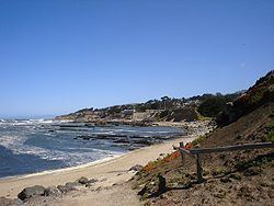
Due to the marine air currents off the Pacific Ocean, Moss Beach experiences above average fog levels, but also superior ambient air quality. Note the everpresent fog in the photo to the right (the circular blotches are not a special effect, but a result of the droplets formed on the camera lens cover). Situated along the coast of Moss Beach is the Fitzgerald Marine Reserve, a California designated area of Special Biological Significance. The reserve boasts a scenic blufftop trail through ancient cypress groves overlooking the Pacific Ocean, historically interesting tidepools and a variety of significant marine animals and pelagic birds. The unique outcroppings along the beach are part of the Franciscan formation, a favorite of local geologists.
Montara State Marine Reserve & Pillar Point State Marine Conservation Area extend offshore from Moss Beach. Like underwater parks, these marine protected areas help conserve ocean wildlife and marine ecosystems.
An occurrence of the rare plant Hickman's potentilla, Potentilla hickmanii was observed by E.C. Suttliffe in 1933 in the vicinity of the mouth of San Vicente Creek within Moss Beach. This colony was not further documented for decades, but another colony was discovered toward the end of the 20th century north of Moss Beach. The plant was listed as an endangered species by the United States government in 1998, and had previously been listed as California endangered in 1973.
Off State Route 1, one finds the famous restaurant Moss Beach Distillery, an architecturally and historically noteworthy building located upon a cliff with ocean views. This present day restaurant has its roots in bootleg liquor during Prohibition. This building is an official California Point of Historical Interest [1] and includes its own ghost (the Blue Lady) which has been featured in a number of ghost hunting programs including Unsolved Mysteries. Sci-Fi's Ghost Hunters recently found their paranormal claims to be fraudulent by revealing that owners of the distillery have created various hoaxes simulating paranormal activity. Noted travel author Karen Brown operates the Seal Cove Inn adjacent to the reserve.