
Country Norway District Lofoten Area rank 374 in Norway Population 1,116 (2012) Official language form Norwegian Language | County Nordland Administrative centre Reine Demonym(s) Moskenesfjerding Local time Sunday 11:56 AM | |
 | ||
Weather -3°C, Wind E at 11 km/h, 78% Humidity Area 118.6 km² (110.3 km² Land / 8.32 km² Water) Points of interest Lofoten, Reinebringen, Lofoten Stockfish Museum, Reinefjorden, Norwegian Fishing Village M | ||
Moskenes is a municipality in Nordland county, Norway. The municipality comprises the southern part of the island of Moskenesøya in the traditional district of Lofoten. The administrative centre of the municipality is the village of Reine. Other villages include Sørvågen, Hamnøy, and Å.
Contents
- Map of Moskenes Norway
- General information
- Name
- Coat of arms
- Churches
- Attractions
- Government
- Municipal council
- Geography
- Notable residents
- References
Map of Moskenes, Norway
General information
The municipality was established on 1 July 1916 when the southern part of Flakstad municipality was separated to become Moskenes. Initially, Moskenes had a population of 1,306.
On 1 January 1964, the municipalities of Flakstad and Moskenes were reunited, this time under the name "Moskenes". Prior to the merger, Moskenes had 2,001 residents and the new municipality of Moskenes had 4,068 residents. This new municipality did not last long because on 1 January 1976, Flakstad broke away again to once again form a separate municipality. This left Moskenes with 1,705 residents.
Name
The municipality (originally the parish) is named after the old Moskenes farm ("Muskenes" – 1567), since the first church was built there. The first element is probably derived from the word mosk/musk which means "sea spray" and the last element is nes which means "headland". (See also Moskenstraumen.)
Coat-of-arms
The coat-of-arms is from modern times. They were granted on 12 September 1986. The arms show a white vortex spiral on a blue background. Vortexes or whirlpools, such as the Moskenstraumen, appear in the channel just south of the island of Moskenes when the tide comes in, making it a hazardous channel.
Churches
The Church of Norway has one parish (sokn) within the municipality of Moskenes. It is part of the Lofoten deanery in the Diocese of Sør-Hålogaland.
Attractions
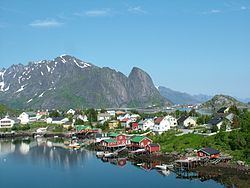
Moskenes is among the most scenic municipalities in all Norway, and the picturesque fishing villages of Hamnøy, Reine, Sørvågen, Moskenes, Å, and Tind have a dramatic backdrop of jagged peaks rising above the Vestfjorden. The historic Glåpen Lighthouse is located just east of Sørvågen.
Between Lofotodden, the southwestern tip of the Lofoten chain, and the offshore island of Mosken, there is the tidal current of Moskenstraumen. This is better known internationally as the Maelstrom, feared by all sailors. On the isolated northwestern coast of the island, there are also interesting Stone Age cave paintings. The highest mountain is Hermannsdalstinden at 1,029 metres (3,376 ft).
Government
All municipalities in Norway, including Moskenes, are responsible for primary education (through 10th grade), outpatient health services, senior citizen services, unemployment and other social services, zoning, economic development, and municipal roads. The municipality is governed by a municipal council of elected representatives, which in turn elect a mayor.
Municipal council
The municipal council (Kommunestyre) of Moskenes is made up of 11 representatives that are elected to every four years. Currently, the party breakdown is as follows:
Geography
The municipality of Moskenes lies near the southern end of the Lofoten archipelago on the southern part of the island of Moskenesøya. The Vestfjorden lies to the east, the Moskenstraumen strait lies to the south, and the Norwegian Sea lies to the west. The municipality of Flakstad lies to the north (on the northern part of the island) and the island municipality of Værøy lies about 20 kilometres (12 mi) to the south.