
Restrictions: No commercial vehicles Length 4.88 km | Counties: Bronx County The Bronx | |
 | ||
North end: | ||
muninyc east mosholu parkway jerome avenue bedford park bronx 10467
The Mosholu Parkway is a hybrid freeway-standard parkway and grade-level roadway in the New York City borough of the Bronx, constructed from 1935 to 1937 as part of the roadway network created under Robert Moses. The roadway extends for 3.0 miles (4.8 km) between the New York Botanical Garden (where its southeast end meets the Bronx River Parkway) and Van Cortlandt Park (where its northwest end meets the Henry Hudson Parkway). The New York City Department of Transportation is responsible for the operation and maintenance of the roadway while the New York City Department of Parks and Recreation is responsible for the surrounding rights-of-way. The parkway is designated as New York State Route 908F (NY 908F), an unsigned reference route, by the New York State Department of Transportation.
Contents
- muninyc east mosholu parkway jerome avenue bedford park bronx 10467
- Map of Mosholu Pkwy Bronx NY USA
- Driving from the mosholu parkway to major daegan expressway in the bronx new york
- Route description
- History
- Major intersections
- References
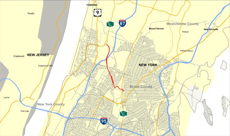
Map of Mosholu Pkwy, Bronx, NY, USA
Driving from the mosholu parkway to major daegan expressway in the bronx new york
Route description
The Mosholu Parkway begins at exit 8E of the Bronx River Parkway. It heads northward as an arterial boulevard through the northern parts of the Bronx. The highway crosses through Bedford Park, passing Bainbridge Avenue. It intersects with the Grand Concourse afterwards, with Jerome Avenue, Sedgwick Avenue and West Gun Hill Road soon after. Within Van Cortlandt Park, the parkway becomes a limited-access freeway, with exits for the southbound Major Deegan Expressway (Interstate 87) and the Henry Hudson Parkway near its northern terminus at the Westchester County line (where it turns into the Saw Mill River Parkway).
A bikeway, part of the East Coast Greenway, runs along the northeast side of the parkway from Bronx Park to Van Cortlandt Park, connecting through the park to other trails and playing fields and to Broadway.
History
"Mosholu" is an Algonquin word meaning "smooth stones" or "small stones", and was first applied to the nearby creek now known as Tibbetts Brook. The southern end of the parkway was once home to another creek, running under what is now Middlebrook Road, which supplied water to a British fort located on old Van Cortlandt Avenue East during the American Revolutionary War.
Major intersections
The entire route is in the New York City borough of the Bronx. All exits are unnumbered.