
Elevation 540 m | Reference no. 323 Local time Saturday 6:32 PM | |
 | ||
Weather 20°C, Wind SW at 8 km/h, 58% Humidity | ||
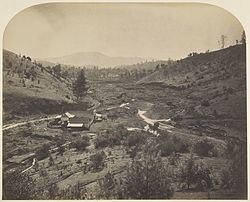
Mormon Bar is an unincorporated community in Mariposa County, California. It is located 2 miles (3.2 km) south-southeast of Mariposa, at an elevation of 1772 feet (540 m). Mormon Bar is located near State Route 49.
Map of Mormon Bar, CA 95338, USA
It was settled during the California Gold Rush. Mormons occupied the place during the winter of 1849/50. It was first mined by members of the Mormon Battalion in 1849. They did not stay very long, and other miners came and occupied the site.
At one time there was a significant Chinese presence there.
Mormon Bar is California Historical Landmark #323.
It is somewhat of a ghost town, and is listed on many maps and ghost town travel guides as such.
References
Mormon Bar, California Wikipedia(Text) CC BY-SA