
District Šumperk Elevation 243 m Local time Saturday 4:49 PM | Postal code 789 82 Area 12.15 km² | |
 | ||
Weather 9°C, Wind W at 40 km/h, 73% Humidity Points of interest Moravičanské jezero, Doubrava, Kačení louka | ||
Moravičany is a village and municipality (obec) in Šumperk District in the Olomouc Region of the Czech Republic.
Map of 789 82 Moravi%C4%8Dany, Czechia
The municipality covers an area of 12.15 square kilometres (4.69 sq mi), and has a population of 1,198 (as at 2 October 2006).
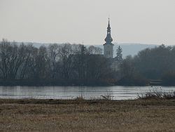
Moravičany lies approximately 24 kilometres (15 mi) south of Šumperk, 29 km (18 mi) north-west of Olomouc, and 186 km (116 mi) east of Prague. The most important landmark in the village is Saint George's Church.
References
Moravičany Wikipedia(Text) CC BY-SA