
Length 77 km Basin area 699.3 km² | - elevation 1,611 ft (491 m) - elevation 610 ft (186 m) Discharge 8.359 m³/s | |
 | ||
- left West Fork Montreal River - average 295.2 cu ft/s (8 m/s) (2006) Source Pine Lake, Iron County, Wisconsin | ||
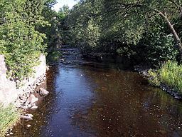
The Montreal River is a river flowing to Lake Superior in northern Wisconsin and the Upper Peninsula of Michigan in the United States. It is 47.8 miles (76.9 km) long and drains approximately 270 square miles (700 km2) in a forested region. For most of its length, the river's course defines a portion of the Wisconsin–Michigan border. The Ojibwe name for the river is Gaa-waasijiwaang, meaning "where there is whitewater".
Map of Montreal River, Ironwood Charter Township, MI, USA
The Montreal River issues from Pine Lake in the town of Oma in eastern Iron County in northern Wisconsin. It flows initially northwardly to the boundary between Iron County and Gogebic County, Michigan, then northwestwardly along the state line, past the 'twin cities' of Hurley, Wisconsin and Ironwood, Michigan. Downstream of Ironwood the river passes over Saxon Falls and Superior Falls and enters Oronto Bay on the southwestern shore of Lake Superior, approximately 15 miles (24 km) northwest of Ironwood, at Michigan's westernmost point.
There are four named waterfalls on the Montreal River. Starting below U.S. Route 2 and going downstream (north), they are Peterson Falls, Interstate Falls, Saxon Falls, and Superior Falls.
The West Fork Montreal River issues from Island Lake in central Iron County and flows 24.7 miles (39.8 km) generally northwardly, roughly in parallel to the Montreal River, past the city of Montreal, Wisconsin. It flows into the Montreal River downstream of Hurley. There are four named waterfalls on the West Fork Montreal River: Kimball Falls, Rock Cut Falls, Gile Falls, and Spring Camp Falls.