
Prominence 855 m | Elevation 2,890 m | |
 | ||
Listing Alpine mountains 2500-2999 m Easiest route South-East slopes from Rifugio Selleries Similar Punta Cristalliera, Monte Rocciavrè, Rocciamelone, Monte Albergian, Monte Robinet | ||
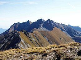
Monte orsiera 2878m podejscie 12 07 2008
Monte Orsiera is a mountain in the Cottian Alps belonging to the Province of Turin (Italy).
Contents
- Monte orsiera 2878m podejscie 12 07 2008
- Map of Monte Orsiera 10060 Roure Metropolitan City of Turin Italy
- Monte orsiera 2878m szczyt 12 07 2008
- Etymology
- Geography
- SOIUSA classification
- Nature conservation
- Maps
- References
Map of Monte Orsiera, 10060 Roure, Metropolitan City of Turin, Italy
Monte orsiera 2878m szczyt 12 07 2008
Etymology
The English translation of Monte Orsiera can be Mountain of the bears, an animal which in Piedmont became extinct between the end of 18th century and the beginning of 19th century.
Geography
Mount Orsiera is the highest mountain of the long ridge which, starting from Sestriere, divides the Susa Valley from the Chisone valley.
SOIUSA classification
According to SOIUSA (International Standardized Mountain Subdivision of the Alps) the mountain can be classified in the following way:
Nature conservation
The mountain and its surrounding area are included in a regional nature park called Parco naturale Orsiera - Rocciavrè, which also is the SIC (Site of Community Importance) of code IT1110006.
Maps
References
Monte Orsiera Wikipedia(Text) CC BY-SA