
Mountain type Stratovolcano | Elevation 654 m | |
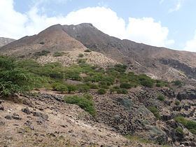 | ||
Monte Graciosa (Portuguese meaning “gracious mountain”) is a third tallest mountain and ranges in the island of Santiago in Cape Verde in the northern part northeast of the town of Tarrafal. Its elevation is 645 m. Monte Graciosa has been a protected area since 2003. The park land includes Ponta Preta.
Contents
Map of Monte Graciosa, Cape Verde
Geography
The mountain is located just east of the Baía de Tarrafal.
Topography
Monte Graciosa are the three main important summits on the island after Serra da Malagueta (1,064 m) and Pico da Antónia (1,394 m) to the south.
Geology
The mountain mainly composes of phonolitic rocks and are covered with basalt layers in the achada (plateau) area and descends to the ocean. The bast features andesite and nepheline rocks with fluid texture, formed by feldspathic rocks including andesine and labradorite.
History
During the Ice Age, the elevation was over 750 meters between 15000 and 9000 BC, around 6000 to 5000BC, its elevation measured below 700 meters.
Park area
The natural park features about 2.4% of the endemic plants in the country, notably Campylanthus glaber ssp. glaber (alecrim brabo), Euphorbia tuckeyana, Kickxia webbiana (agrião de rocha), Kickxia dichondrifolia, Nauplius daltonii ssp. daltonii, Paronychia illecebroides (palha de formica), Sarcostemma daltonii (gestiba) and Siderxylon marginata (marmolano or marmulano)
Other plants in the park includes Jatropha curcas and Prosopis juliflora (American acacia) founded higher than 200 m altitude.
Tourism
Other landmarks includes Farol da Ponta Preta located in the northwest end of the island west of the mountain. The lighthouse was featured in a Cape Verdean stamp in 2004.