
Altitude 595 m (1,952 ft) Periods 6th century BC Public access yes | Type settlement Cultures Sicans, Greeks Period 6th century BC | |
 | ||
Archaeologists Paolo Orsi, Piero Orlandini | ||
Monte Bubbonìa is a 595 metre high hill located in the comune of Mazzarino, about twenty kilometres from the city of Gela. It consists of three platforms, descending from west to east (i.e. the westernmost platform is also the highest).
The site is reached by travelling along the SS 117 Gela-Catania, taking the turn-off for Piazza Armerina, driving for 9 kilometres, until a side road appears on the left, the old road to Mazzarino, marked by a sign which shows the street on an ancient Roman route map known as the Itinerarium Antonini.
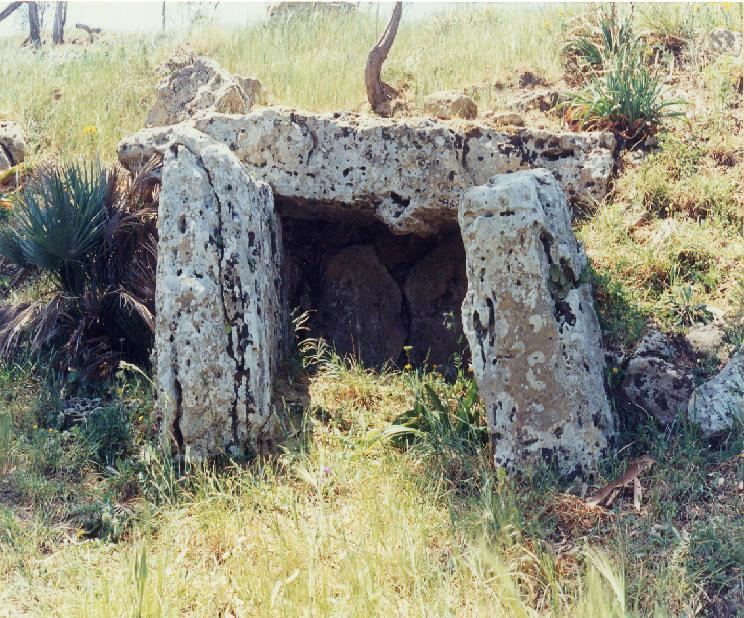
The shape of the hill, from a geological point of view, is relatively recent, with the Miocene limestone base covered by Pleistocene marl with silt and quartz grains, then finally by very red sand which is very crumbly and dusty. Below the curb of a dirt road which runs up the east side of the hill towards the acropolis, there is a 2.2 metre long chamber dolmen, the shape of which has similarities to structures in Sardinia and Apulia.
On the summit of the mountain, Paolo Orsi discovered an ancient city which the archaeologist Piero Orlandini later identified as the Sican settlement of Maktorion, known from Herodotus 7.53. However, the ruins do not seem to predate the 6th century BC, and this makes Orlandini's identification unlikely.