
 | ||
Management California Department of Parks and Recreation Similar Gray Whale Cove Stat, Point Montara Light, Pacifica State Beach, Fitzgerald Marine Reserve, Caspar Headlands State Bea | ||
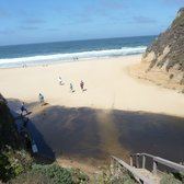
Montara State Beach is a beach located eight miles north of Half Moon Bay on State Route 1, USA. Operated by California State Department of Parks and Recreation under the San Mateo Coast Sector Office. It is one of the cleanest in the state.
Contents
Map of Montara Beach, Montara, CA 94019, USA
Montara State Marine Reserve & Pillar Point State Marine Conservation Area extend offshore from Montara State Beach. Like underwater parks, these marine protected areas help conserve ocean wildlife and marine ecosystems.
History
The first European land exploration of Alta California, the Spanish Portolà expedition, camped in this area on October 30, 1769, possibly at Martini Creek, which reaches the sea at Montara beach (Bolton says San Vicente Creek, farther south). Franciscan missionary Juan Crespi noted in his diary, "We stopped not far from the shore at the foot of some hills which prevent us from passing along the beach. They form a valley sheltered from the north, from which flows an arroyo with plenty of good water...on account of the large number of mussels which they found on this beach, very good and large, the men called it Punta de las Almejas."