
Width 10 km (6 mi) Elevation 1,370 m Peak Mount Belinda | Length 12 km (7.5 mi) Highest elevation 1,370 m (4,490 ft) Population Uninhabited Area 110 km² Island group South Sandwich Islands | |
 | ||
Montagu island pipe line
Montagu Island is the largest of the South Sandwich Islands, located in the Weddell Sea off the coast of Antarctica. It is a part of the British Overseas Territory, South Georgia and the South Sandwich Islands. It is located 60 km (37 mi) northeast from Bristol Island and 62 km (39 mi) south from Saunders Island.
Contents
- Montagu island pipe line
- Map of Montagu Island SIQQ 1ZZ South Georgia and the South Sandwich Islands
- Geography
- Mount Belinda
- References
Map of Montagu Island, SIQQ 1ZZ, South Georgia and the South Sandwich Islands
The island was first sighted by James Cook in 1775, and named after John Montagu, 4th Earl of Sandwich and the First Lord of the British Admiralty at the time of its discovery. The first recorded landing was made by the Norwegian whaler and explorer Carl Anton Larsen in 1908.
Geography
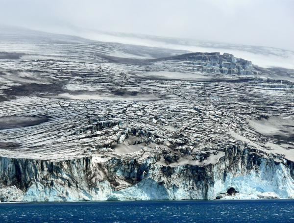
The desolate, uninhabited island measures approximately 12 by 10 kilometres (7.5 by 6.2 mi), with over 90% of its surface permanently covered in ice. The volcano Mount Belinda is its most notable geographic feature, rising to 1,370 metres (4,495 ft) above sea level. It was believed to be inactive prior to the sighting of low-level ash emission and suspected lava effusion in 2002 by the British Antarctic Survey.
Mount Belinda
In November 2005, satellite images revealed that an eruption of Mount Belinda had created a ninety metres (295 ft) molten river flowing to the northern shoreline of the island. The event has expanded the area of the island by 0.2 square kilometres (0.1 square miles), and provided some of the first scientific observations of volcanic eruptions taking place underneath an ice sheet.
As of 8 August 2009, imaging on Google Earth shows the volcano to be active with a noticeable plume and lava flow. The effects on the ice sheet are visible.