
Elevation 362 m | ||
 | ||
Similar Cliffe Hill, Stenbury Down, St Boniface Down, Rock of Oëtre, Buurgplaatz | ||
Mont Pinçon is the highest point of the department of Calvados, in Normandy, with an elevation of 362 metres (1,188 ft). It is in the west of Norman Switzerland about 30 kilometres (20 mi) to the south-west of Caen, near the village of Plessis-Grimoult.
Map of Mont Pin%C3%A7on, 14770 Le Plessis-Grimoult, France
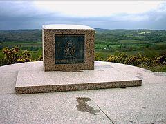
It was the site of many strategic battles in the Battle of Normandy with the Allied attack in Operation Bluecoat. In 1956, Radiodiffusion-Télévision Française (RTF, now TDF) installed a tranmitter pylon over 200 metres (660 ft) high, which still serves most of the Basse-Normandie region.
References
Mont Pinçon Wikipedia(Text) CC BY-SA