
Demonym(s) Monselicensi Postal code 35043 | Elevation 9 m (30 ft) Population 17,603 (2009) Local time Thursday 7:11 PM | |
 | ||
Frazioni Marendole, Monticelli, Ca' Oddo, San Cosma, San Bortolo, Carmine Weather 15°C, Wind SE at 8 km/h, 50% Humidity | ||
"Monselice is the most picturesque town I have seen in Italy. It has an old ruin of a castle upon the hill and thence commands a beautiful and extraordinary view. It lies in the wide plain – a dead level – whereon Ferrara, Bologna, Rovigo, Este, Padua stand and even Venice we could dimly see in the horizon rising with her tiara of proud towers. What a walk and what a wide delightful picture. To Venice 38 miles."
Contents
Map of 35043 Monselice, Padua, Italy
(Ralph Waldo Emerson, Journals, [31 May 1833])
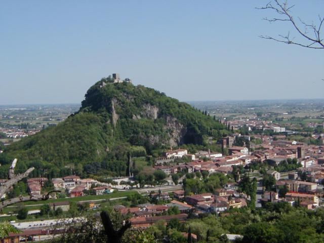
Monselice is a town and municipality (comune) located in northeastern Italy, in the Veneto region, in the province of Padua.
It is about 20 kilometres (12 mi) southeast of the city of Padua, at the southern edge of the Euganean Hills (Colli Euganei).
History
The town's mythological foundation is attributed to the Trojan hero Opsicella. The area shows evidence of human settlement since the Bronze Age.
In Roman times it was known as Mons Silicis, meaning "mountain of flintstone", possibly due to the local quarries of trachyte.
The earliest known documents about Monselice date back to 568 CE and are related to the conquest of the town by the Lombards. The town was under Byzantine rule for a brief period until its conquest by king Agilulf around 602.
During the Comuni period (12th century) the town had its own local self-government. The town was aligned with the Ghibellines against the Guelphs in the political and military fights of the 13th century.
The Ghibelline leader Ezzelino III da Romano improved the town's fortifications and made it one of the main strongholds of the area.
The town was then under the Carraresi (the lords of Padua) rule and in the 15th century it became part of the Republic of Venice.
After a short period of French domination, it was part of the Austrian Empire and, later, of its client Kingdom of Lombardy-Venetia.
In 1866 it became part of the Kingdom of Italy.
Main sights
The modern town lies in a wide valley between the Montericco, elevation 312 metres (1,024 ft), and the Rocca, elevation 110 metres (360 ft), hills (part of the Euganean Hills).
The oldest part of the town lies around the Rocca hill.
In medieval times the Rocca was heavily fortified with five girdle walls that are partially still visible today.
Important points for tourists can be the central square Piazza Mazzini with the medieval Torre Civica (Civic Tower) and the Palazzo del Monte di Pietà(Public Pawn Palace). This building hosts the local touristic promotion board (Pro Loco), that provides information for visits to the town's historical attractions.
Piazza Mazzini square is also the starting point for the promenade walk along Via del Santuario, leading to the most interesting sites of the town, which include:
Culture
A lively market is held every Monday in the town's main streets.
An important fair is traditionally held every year around November 1 (All Saints Day - saint patron day for the town). Attractions include a food and general market, local food stands, fun park, exhibits.
Started in recent years, the "Palio di Monselice" tournament has become a primary attraction. The Palio is held every year in September. It is modeled after medieval horse tournaments and it includes a medieval parade.
Transportation
Monselice is well connected to the major towns of Padua, Venice and Bologna.
Monselice railway station is on the Venice-Padua-Bologna-Florence line, between Padua (North) and Bologna (South). A secondary railway line connects Monselice to the town of Mantua in Lombardy.
The nearest airports are Marco Polo, Venice (VCE), 60 kilometres (37 mi) away, and Marconi, Bologna (BLQ), 100 kilometres (62 mi).
Twin towns
Monselice is twinned with: