
Country United States County Monroe Time zone Central (CST) (UTC-6) Area 34.7 km² Local time Thursday 12:44 PM | State Alabama Elevation 413 ft (126 m) ZIP codes 36460–36462 Population 6,289 (2013) | |
 | ||
Weather 13°C, Wind N at 6 km/h, 26% Humidity University Alabama Southern Community College | ||
Monroeville alabama a walk downtown
Monroeville is a city in Monroe County, Alabama, United States, the county seat of Monroe County. At the 2010 census its population was 6,519.
Contents
- Monroeville alabama a walk downtown
- Map of Monroeville AL 36460 USA
- Monroeville alabama a drive around the square
- History
- Geography
- Demographics
- 2010 census
- Education
- Notable people
- References
Map of Monroeville, AL 36460, USA
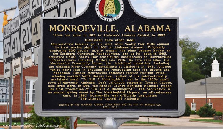
It is known as the hometown of two prominent writers of the post-World War II period, Truman Capote and Harper Lee, who were childhood friends in the 1930s. Lee's 1960 novel, To Kill a Mockingbird, earned her the Pulitzer Prize. The lasting fame of To Kill a Mockingbird became a tourist draw for the town. In 1997, the Alabama Legislature designated Monroeville and Monroe County as the "Literary Capital of Alabama."
Monroeville alabama a drive around the square
History
The town was initially known as Walker's Mill and Store, named for Major Walker, the area's first white settler. In 1832, the county seat was relocated to Monroeville from Claiborne on the Alabama River. The settlement was briefly renamed "Centerville" due to its location in the center of the county, but then it was formally changed to Monroeville. The town was not formally incorporated until April 15, 1899.
Geography
Monroeville is located at 31°31′5″N 87°19′39″W (31.518075, -87.327543).
According to the U.S. Census Bureau, the city has a total area of 13.4 square miles (34.7 km2), of which 13.4 square miles (34.6 km2) is land and 0.0077 square miles (0.02 km2), or 0.05%, is water.
Demographics
As of the census of 2000, there were 6,862 people, 2,687 households, and 1,870 families residing in the city. The population density was 525.8 people per square mile (203.0/km²). There were 3,016 housing units at an average density of 231.1 per square mile (89.2/km²). The racial makeup of the city was 53.09% White, 44.84% Black or African American, 0.38% Native American, 0.58% Asian, 0.15% from other races, and 0.96% from two or more races. 0.90% of the population were Hispanic or Latino of any race.
There were 2,687 households out of which 34.3% had children under the age of 18 living with them, 48.0% were married couples living together, 18.9% had a female householder with no husband present, and 30.4% were non-families. 28.0% of all households were made up of individuals and 11.7% had someone living alone who was 65 years of age or older. The average household size was 2.46 and the average family size was 3.04.
In the city, the population was spread out with 27.7% under the age of 18, 8.9% from 18 to 24, 24.6% from 25 to 44, 22.2% from 45 to 64, and 16.6% who were 65 years of age or older. The median age was 36 years. For every 100 females there were 82.0 males. For every 100 females age 18 and over, there were 76.4 males.
The median income for a household in the city was $28,229, and the median income for a family was $36,476. Males had a median income of $35,600 versus $20,184 for females. The per capita income for the city was $17,070. About 20.4% of families and 23.0% of the population were below the poverty line, including 29.0% of those under age 18 and 19.2% of those age 65 or over.
2010 census
As of the census of 2010, there were 6,519 people, 2,656 households, and 1,723 families residing in the city. The population density was 488 people per square mile (188.4/km²). There were 3,056 housing units at an average density of 228.1 per square mile (88.3/km²). The racial makeup of the city was 55.7% White, 42.1% Black or African American, 0.3% Native American, 0.3% Asian, 0.3% from other races, and 1.2% from two or more races. 0.8% of the population were Hispanic or Latino of any race.
There were 2,656 households out of which 28.4% had children under the age of 18 living with them, 39.8% were married couples living together, 21.1% had a female householder with no husband present, and 35.1% were non-families. 30.5% of all households were made up of individuals and 12.9% had someone living alone who was 65 years of age or older. The average household size was 2.37 and the average family size was 2.95.
In the city, the population was spread out with 24.6% under the age of 18, 9.4% from 18 to 24, 21.8% from 25 to 44, 26.2% from 45 to 64, and 18.0% who were 65 years of age or older. The median age was 40.2 years. For every 100 females there were 87.7 males. For every 100 females age 18 and over, there were 88.5 males.
The median income for a household in the city was $31,593, and the median income for a family was $49,548. Males had a median income of $41,324 versus $31,033 for females. The per capita income for the city was $20,553. About 23.3% of families and 27.7% of the population were below the poverty line, including 37.3% of those under age 18 and 19.0% of those age 65 or over today.
Education
Monroeville is home to Alabama Southern Community College, a state-supported, fully accredited, comprehensive two-year college serving southwest Alabama with its main campuses in Monroeville and Thomasville.