
Carries pedestrian traffic Design Bridge tower Construction begin 1272 Width 7.3 m Piers in water 2 | No. of spans 3 Total length 35 m Body of water River Monnow Bridge type Deck arch bridge | |
 | ||
Locale Monmouth, Monmouthshire, Wales Address Monnow St, Monmouth NP25 3EG, UK Similar Shire Hall - Monmouth, Church of St Thomas the Martyr, The Kymin, St Mary's Priory Church, Kings Head Hotel - Mo | ||
The olympic torch relay crossing monnow bridge monmouth wales
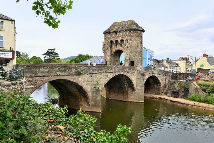
Monnow Bridge in Monmouth, Wales crosses the River Monnow (Welsh: Afon Mynwy) some 500m above its confluence with the River Wye. It is the only remaining fortified river bridge in Great Britain with its gate tower standing on the bridge. Such bridge towers were common across Europe from medieval times but many were destroyed as a consequence of diminishing defensive requirements, urban expansion, and the increasing demands of traffic and trade. The historical and architectural importance of the bridge, and its rarity, are reflected in its status as a Scheduled Monument and a Grade I listed building.
Contents
- The olympic torch relay crossing monnow bridge monmouth wales
- Monnow bridge monmouthshire cintec repairs by protectahome ltd 1
- 13th14th centuries
- 15th19th centuries
- 20th21st centuries
- Depictions in art
- Architecture
- References
Begun, according to tradition, in 1272, the stone bridge replaced a 12th-century Norman timber bridge. From its construction, it played a significant, if ineffectual, role in the defence of Monmouth, in the medieval era, in the English Civil War and during the Chartist uprising. It also served as a gaol, a munitions store, a lodge, an advertising hoarding, a focus for celebrations and, most significantly, as a toll gate. Much of the medieval development of the town of Monmouth was funded by the taxes and tolls the borough was entitled to raise through Royal charter. The tolls were collected through control of the points of entry to the town, including the Monnow Gate.
Built predominantly of Old Red Sandstone, the bridge was the subject of significant reconstruction and rebuilding in the 18th and 19th centuries. In those centuries, it also became a popular subject for artists; amongst others, Turner, Gastineau and Cotman produced sketches of the bridge and gate. In the 20th century, it suffered increasing damage as higher volumes of traffic and the use of ever-larger vehicles led to a number of serious accidents. In the 21st century, the construction of a new road crossing to the south enabled the pedestrianisation of the bridge.
Monnow bridge monmouthshire cintec repairs by protectahome ltd 1
13th–14th centuries
The existing bridge was completed in the late 13th century, traditionally in 1272 though this date has no supporting documentary evidence. The archaeologist Martin Cook, in his 1998 volume Medieval Bridges, notes the significance of the date 1270 as the start of a period that saw increased bridge-building, due to the "rapid growth of international trade in, for example, textiles and pottery." The Monmouth antiquarian Charles Heath, writing in his Historical and descriptive accounts of the ancient and present state of the town of Monmouth published in 1804, recorded that the bridge's "foundation is so ancient that neither history or tradition afford any light respecting the date of its erection." Heath drew directly from the earlier guide to The Antiquities of England and Wales written by Francis Grose and published in 1773. The civil engineer Edwyn Jervoise, author of The Ancient Bridges of Wales and Western England, suggested that the absence of an evidential record was due to the destruction of "the archives of the Duke of Beaufort at Raglan Castle in the 17th century." However, this is unlikely as the gatehouse did not come into the possession of the Somersets until the 19th century.
The stone bridge replaced an earlier wooden structure. Work on flood defences in 1988 revealed remains of a wooden bridge directly under the existing one, and dendrochronological analysis indicated that its timber came from trees felled between 1123 and 1169. Some sources suggest that the earlier wooden bridge, and the nearby Church of St Thomas the Martyr, were damaged by fire in the Battle of Monmouth, between supporters of Henry III and the forces of Richard Marshal, Earl of Pembroke, in 1233. The site of the battle is a matter of debate, however, as is the specific bridge involved; the local historian Keith Kissack argued that the battle was fought on Vauxhall (Castle) Field, below Monmouth Castle, and some way from Monnow Bridge, while other historians continue to place the battle at Overmonnow.
The gatehouse, called Monnow Gate, which gives Monnow Bridge its now unique appearance, was added at the end of the thirteenth or start of the 14th centuries, some thirty years after the bridge itself was built. In 1297 Edward I provided a murage grant in favour of Monmouth, in response to a request from his nephew Henry of Lancaster. The grant allowed the townspeople to build the town walls and gates for defence and protection, and the construction of the gate-tower formed part of these improvements. By 1315, this work was still incomplete or required repair, as the original authority was renewed on 1 June 1315. At that time, the bridge would have been much narrower than now, with all traffic passing beneath a portcullis – the grooves for the lowering of which are still visible – and through a single arch. The prominent arched machicolations were added at an unknown date in the mediaeval period, possibly in the late 14th century. The gate formed part of the enceinte encircling Monmouth.
Kissack contends that the gate house was ineffective in defensive terms, as the Monnow could easily be crossed on foot just upstream. The Victorian antiquarian Mary Ellen Bagnall-Oakeley, who wrote the first history of the bridge and gate in 1902, was of a similar view, describing the tower as; "A little fortress complete in itself, though of course, useless in time of war." She went further, arguing that; "This tower was not in any way connected with the fortification walls of the town" and that the gate-tower was erected solely; "for the purpose of taking tolls." Later historians dispute this, arguing for a dual purpose for the bridge and gate. As well as providing some defence for the Anglo-Norman population of the town against attacks by the Welsh from the surrounding areas, it served as a barrier to collect tolls from those attending markets. Tolls were authorised in the Patent Rolls of 1297 and 1315, and in subsequent town charters. Kissack gives details of the wide variety of items on which tariffs could be levied in his reproduction of the charter of 1297. These included "five fat hogs", a "horse-load of honey" and "a thousand (roofing) nails".
15th–19th centuries
Neither Monmouth nor its castle were attacked in the rebellion of Owain Glyndŵr in the early 1400s, although nearby Abergavenny and Grosmont were burned down in the uprising, but the unrest of the period did have a negative impact on the development of the town. Nevertheless, the bridge continued its important function as a toll-gate. Philip Jones, Member of Parliament for Monmouth Boroughs in 1589, bequeathed a sum of about £120, the rent from his lands and houses at 'Bayliepitte', to the mayor and bailiffs of Monmouth on condition the borough exempt those people passing through Monnow Bridge Gate, or coming into Monmouth with cattle, from paying tolls on fair days.
In the 16th century, the antiquarian John Leland described the bridge in one of his itineraries; "From Monk's Gate the wall extends Westwards to the river Monnow. In the wall are four gates: Monk's Gate, East Gate and Wye Gate ... and Monnow Gate which is above the bridge crossing the river Monnow." A visual depiction of the bridge and gate is included in John Speed's work, The Theatre of the Empire of Great Britain, published in 1611. His map of Monmouthshire includes an inset map of the town, and shows the Monnow Bridge and Gate, as well as a similar gatehouse on the Wye Bridge.
In the Civil War, the town changed hands several times, and in 1645 the bridge was seized by Royalist soldiers from Raglan, in a failed attempt to retake the town from the Parliamentarian forces under Colonel Kyrle. Kissack describes the engagement as "the most resolute Royalist attack made (on) Monmouth" which saw eight of Kyrle's opponents killed and five captured." By 1705 the bridge and gatehouse required maintenance: the original battlements were replaced with solid walls, and the building was refitted to form a two-storey dwelling house, with timber and lath extensions projecting over the river. The house was then leased to a resident gatekeeper, responsible for repairing and maintaining the building. Part of it remained in use as a lock-up, and both the bridge and the gatehouse were again repaired between 1771 and 1775. Trade continued to be central to the importance of the bridge. The Monmouthshire writer and artist Fred Hando records that, on a single Saturday in the early 18th century, "500 horses each carrying five bushels of corn entered by way of the Monnow gate."
In 1804 Charles Heath recorded, "the interior has nothing worthy of attention and the only purpose to which it is employed is an occasional guardhouse, or powder room, for the military, when stationed at Monmouth." The gatehouse had by this point been abandoned as a dwelling. The historian William Coxe in his two volume guide, An Historical Tour of Monmouthshire, published in 1801, incorrectly described the bridge as pre-dating the Norman Conquest and recorded that; "It commanded the passage of the Monnow and was a barrier against the Welsh." The lean-to extensions, including the guardhouse were demolished around 1815. In 1819 a pedestrian passageway was driven through the building on the upstream side, to help relieve the flow of traffic across the bridge. Before 1830, the gatehouse was owned by Monmouth Corporation, but was then formally transferred to the Duke of Beaufort as part of a property exchange. The gatehouse roof was reconstructed in 1832, with deeper eaves and four decorative corbels on each side. Further fortification took place in 1839. A second passageway was added on the downstream side of the arch in 1845. Since then, the structure has remained essentially unchanged, through regular maintenance and repair.
In 1839 the gatehouse was garrisoned during the Newport Rising, the authorities fearing a Chartist attack which did not materialise. Later guidebooks suggest that the three loopholes visible on the tower were "knocked through" at this time "for musketry in anticipation of the advance of the Chartists" but Rowlands shows that the apertures are clearly visible in illustrations of the gatetower long before 1839.
Until the mid-19th century, the gatehouse was the scene of annual battles, or "muntlings", between rival gangs from "Up-Town" – the main town of Monmouth – and Overmonnow or "Cappers' Town", so called because it was the traditional home of those who made Monmouth caps. These took place on 1 and 29 May, the youths arming themselves with besoms or "muntles" reinforced with stones. The altercations were banned in 1858. The bridge was also used as a focus for significant local and national celebrations; it was decorated with flags and lights to commemorate the coming of age of John Maclean Rolls, eldest son of Monmouthshire grandee Lord Llangattock; and as an unofficial advertising hoarding.
20th–21st centuries
From 1889 to 1902 an extensive programme of conservation was carried out on the bridge; this began with the prevention of the potential collapse of the tower by the insertion of metal rods to tie the two faces of the tower together, the four round plates at the ends of these two rods can still be seen. In 1892, work began on the arches and piers of the bridge as it was discovered that riverbed erosion had seriously undermined the piers. This period of conservation was ended with maintenance being carried out on the gate tower exterior from the mid-1890s to 1897. Roof guttering and downpipes were added, badly eroded stone was replaced with squared blocks of old red sandstone and the cruciform arrow slit on the front, left, of the tower was restored to make it symmetrical. In April 1893, the bridge's first street lamp had been erected by the town council. In the late 1920s the top portion was replaced with twin electric lamps. In the 1960s the lamps were removed completely and since 1991 the bridge has been floodlit.
In 1900, ownership of the gatehouse was transferred from Henry Somerset, 9th Duke of Beaufort to Monmouthshire County Council, as part of the disposal of the entirety of the Somersets' land holdings in Monmouthshire. The gift is recorded on a brass plaque attached to the gatehouse. Having previously referenced the bridge in her wider study, The Fortifications of Monmouth, published in 1896; the local antiquarian Mary Ellen Bagnall-Oakeley published the first history of the bridge and gatehouse, Monnow Bridge Tower, in 1903.
In 1963 Fred Hando, who recorded points of interest and history around Monmouthshire in a series of articles for the South Wales Argus between the 1920s and 1960s, wrote a description of the gatehouse, referencing the small museum then located in the upstairs room. Hando mentions the "beautifully executed" copies of the patent rolls issued by Edward I in 1296-7 and by Edward II in 1315 which recorded the items on which tolls could be levied in order to fund the fortifications for Monmouth.
In the 20th century the growth of traffic using the road, with resulting accidents and congestion on what was a humpback bridge with poor visibility and narrow approach roads, led to many proposals to by-pass the bridge. The damaging impact of traffic on ancient structures had long been recognised; in 1721 The Society of Antiquaries had paid ten shillings "for setting down two oak-posts to secure Waltham Cross from injury by carriages." The bridge and gate was formally recognised as an Ancient Monument in 1923, and proposals for a new road bridge began to be made about the same time. The new A40, built in 1965/66, relieved the town of much through traffic, and a town centre plan, prepared by the District Council, in 1981 again proposed a new bridge. A serious accident on 18 May 1982, when a double-decker bus attempted to cross the bridge into Monmouth, caused very significant damage and closed the bridge for a month while major repairs were undertaken.
Damage to the bridge and gate through accidents continued, and in the early 1990s two drivers, whose vehicles significantly exceeded the weight and height limits for the bridge, were prosecuted. In 1999 a feasibility study was undertaken by the engineers Ove Arup and Partners for a bridge further along from the Monnow bridge, but the scheme was not progressed. However, a new road bridge over the Monnow, for local traffic within the town, was eventually built and opened on 15 March 2004, allowing the old bridge to become pedestrianised. The closure to traffic also enabled a significant repair programme to be undertaken, in part funded by the Welsh Government and the European Union. To commemorate the Millennium, a mosaic pillar was installed next to the bridge by Monmouth Town Council. The circular plinth is made of 40 ceramic tiles which illustrate over 2,000 years of local history. After further conservation and repair, the gatehouse was formally re-opened, on a weekly basis, in 2014.
Depictions in art
Monnow Bridge and Gatehouse has been a popular subject for artists, particularly since the development of the Picturesque movement in the later 18th century. William Gilpin in his Observations on the River Wye, and Several Parts of South Wales, etc. Relative Chiefly to Picturesque Beauty; made in the Summer of the Year 1770, published in 1782, generated considerable interest in the attractions, natural and man-made, of South Wales, and heralded the development of the Wye Tour as an alternative to the Grand Tour. A late-18th-century watercolour by Michael Angelo Rooker is now in the Monmouth Museum. The noted architectural watercolourist Samuel Prout painted the bridge in the late 18th or early 19th century in a study now held at the Yale Center for British Art in Connecticut. In 1795, J. M. W. Turner sketched the bridge and gatehouse during one his annual Summer sketching tours. Henry Gastineau created a much reproduced image in 1819. Due to a printing error, which confused his drawing of the Bridge with one of the tower at Raglan Castle on the opposite page of the printed collection, Gastineau's image often appears with the title Gate and Bridge, Ragland. John Sell Cotman sketched the bridge in the early 19th century, his drawing clearly showing the overhanging accommodation and guardhouse that were later removed. Joshua Cristall produced a similar pencil sketch in 1803. The artist of the American West Thomas Moran produced an undated pencil drawing of the bridge which is printed in his Field Sketches.
Architecture
The bridge is 34.80 metres (114.2 ft) in length and 7.30 metres (24.0 ft) wide. The gate stands 11.00 metres (36.09 ft) high. It has three arches standing on piers. The two piers which stand on the bed of the Monnow form cutwaters. The undersides of the arches are ribbed for reinforcement. The bridge is constructed of seven types of stone, predominantly Old Red Sandstone. The two passageways through the gate are 19th-century insertions. Prior to their construction, the main gateway was the sole means of entry and egress. This opening was defended by a portcullis. The gate tower is elliptical and its western and eastern elevations show considerable differences. The western front has three machicolations over the gate, with murder holes inset. Mary Ellen Bagnall-Oakeley describes them as "a very interesting arrangement." The dating of the machicolations is uncertain but comparison with similar, dated, examples, such as those at Cooling Castle in Kent, suggests a construction period in the 14th century. They cannot be original to the gate, as their positioning would have "obstructed the portcullis had they been present." The eastern front is less decorated and displays evidence of more substantial reconstruction. It has a round-headed window, centrally placed. The pedestrian arches through the bridge also differ in design, the northern being pointed, and the southern having a flat, "Caernarvon", head.
Internally, the gate has a single room, accessed by a stair, and a garderobe. The original internal access was by way of a stone spiral staircase but this was subsequently destroyed and a wooden replacement inserted. The room in the tower measures 36 feet long and 10 feet wide and has an attic and an 18th-century roof, which replaced the medieval parapet. The roof was reconstructed in 1832. From the upper room, the machine cut rafters are clearly visible.
The bridge is one of only two surviving fortified bridges in the United Kingdom, the other example being at Warkworth, Northumberland. There, the gate house stands on land at one end of the bridge, rather than on the bridge itself, and is described by the archaeologist John Steane as "less impressive" than the "superb" Monnow Gate. Such bridge towers were common across Europe and, to a lesser extent, in Great Britain, from medieval times, British examples including the Mardol Gate at Shrewsbury and Froome Bridge in Bristol. However, the lessening of defensive requirements, urban expansion, and the substantial increases in traffic and trade from the 18th century onwards led to the destruction of many of what was once a common bridge type. The rarity of Monnow Bridge and Gate is reflected in its status as a Scheduled Monument and a Grade I listed building; its listing describing it as "an outstanding medieval fortified bridge, now unique in Britain."