
Surface area 695 acres (281 ha) Max. depth 51 ft (16 m) Surface elevation 177 m | Average depth 42 ft (13 m) Settlements Norton Shores, MI Area 2.813 km² Settlement Norton Shores | |
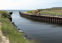 | ||
Mona Lake is a freshwater lake located in Norton Shores just outside the city of Muskegon in the U.S. state of Michigan (Muskegon County). Mona Lake is a sandy bottom lake that flows into Lake Michigan via the Mona Lake channel.
Contents
- Map of Mona Lake Norton Shores MI USA
- 2010 07 12 yosemite tiago pass road 03 mona lake and tuolumne wmv
- Fishing
- Parks and Recreation
- References
Map of Mona Lake, Norton Shores, MI, USA
2010 07 12 yosemite tiago pass road 03 mona lake and tuolumne wmv
Fishing
The lake is an exceptional fishery for big walleyes, Black Crappie, Bluegill, Channel Catfish, Largemouth Bass, Muskellunge (Muskie), Northern Pike, Smallmouth Bass, White Bass, Salmon, and Yellow Perch. There is a public access boat launch with hard-surface ramps on the north shore.
Parks and Recreation
There is a Boating Club on Mona Lake that is open to the public. The boating club features a full service gas station dock, boat launch, full service kitchen, restrooms, Tiki Bar, playground, picnic areas, and a sandy beach
On the south side of Mona Lake is Norton Shores' Ross Park, which is a 43-acre park located Randall Road. Ross Park Features a Sandy Beach Area with playground equipment, a picnic area, a paved walkway and a volleyball area. There is also a Boat parking area for those who want to come to shore.