
First attested 1213 Website Moisei Town Hall Population 9,264 (2011) | Postal code 437195 Area 113 km² Local time Wednesday 8:11 PM | |
 | ||
Weather 4°C, Wind NW at 10 km/h, 82% Humidity | ||
Moisei (Hungarian: Majszin) is a commune in Maramureș County, Romania. Composed of a single village, Moisei, it is one of the oldest communes in Maramureș County, first attested in 1213. This place is well known for the monastery near the village, founded in 1672.
Contents
Map of Moisei 437195, Romania
It is the site of the Moisei massacre which occurred on October 14, 1944, when 39 Romanians and 3 Jews were killed by the Hungarian Army.
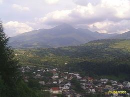
General presentation
Moisei is located in the southeastern part of Maramureș County, at 136 km from Baia Mare, the county seat, at 5 km from Borșa and at 7 km from Vișeu de Sus. The village is located mainly on the Vișeu River’s course, on Dragoș Spring and on Black Spring (Black Valley). Together, these waterways constitute the main landscape of the village, along with the houses that are built on hills up to 800 m high.
The commune is situated in the relief unit called Maramureș Hollow, under the Vișeu corridor. Practically, Moisei is placed at the bottom of Rodnei Mountains, having Pietrosu mountain on its upper side and the Maramureș Mountains to the north. Passage from Lunca Vișeului to the mountain area is made naturally from hills with heights between 600 and 800 m.
The commune has two main roads: DN 17 and DN 18. The total length of the roads and lanes is 44.7 km, of which 15 km are national roads. Moisei also has a Căile Ferate Române train station.