
Province Province of Udine | ||
 | ||
Moggessa di Lá is an abandoned and partly dilapidated northern Italian peasant village with no access road in the Carnic Alps west of Moggio Udinese in the Province of Udine. The second part of the hamlet, Moggessa di Quà, and the neighboring village Stavoli also have no road access. Moggessa Di Lá can be reached by a two-hour walk, which departs from Moggio Udinese, which is located on the A23 motorway.
Contents
Map of 33015 Moggessa di L%C3%A0 Province of Udine, Italy
Historically is Moggessa di Lá, in Friulian Muiesse di lá, in German Klein-Mossach jenseits, that means Little Moos beyond, a medieval foundation of the monastery in Moggio. Despite the altitude of 530 meters above sea level the area is suited for growing vegetables. The microclimate at the foot of Monte Palevierte (at 1,785 metres above the Adriatic / 5,856 ft) is very mild. Since there are no access roads, the village is accessible only by mule tracks. A path leads from Moggio Udinese on Moggessa di Quá after crossing the gorge of Molin-brook after about two hours to the village. In the gorge are the last remnants of the mill to see, which was in operation until 1962 and was almost completely destroyed by an earthquake in 1976.
The trail between the sattlements is unlike after Moggio down, less steep and in better condition, so that you can communicate between the two villages via dirt bike. From the other side Moggessa di Lá is after an hour walking time via a steep narrow road and a river crossing (there is no bridge) of Stavoli from accessing. Stavoli is another mountain village with no access road.
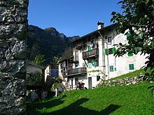
At the entrance of Moggessa di Lá is a small Catholic church. A cemetery does not exist however. Particularly appealing are the narrow allyways, where the farmhouses are concentrated in a small space. The relatively high built houses and partly ruined buildings are very close together. In between, often extend only a few meters wide streets. The clear overgrown fields lie below the village.
Early 20th century the inhabitants lived largely autonomously as self-catering. In winding core take several cobbled streets together. Five houses were inhabited by 2008, but not all year. At the lower edge where the fields begin is the largest and most striking house, an old craftsman house. It has two superimposed arcades whose lower arches are open. Two other still preserved show brick arches of a ruined house near that this style element was used here more often. Until 1960 there was in this village here even a school.
As in neighboring villages, there are also many examples of rural, reduced to essentials architecture, which is characteristic of this poor mountain area. The houses, all of them made of stone, are unexpectedly high, with up to four storeys. In the middle of the villages there are common wells. Many of the wooden balconies on the south side have already expired. Typical are also grown outside of the houses Fireplaces for Fogolâre that open herd in Friuli. The wreck of a Cultivators shows that there is still motorized farm equipment were used, before people have moved away.
The very solitary life in the mountains, especially in winter was a little lighter than water pipes and electricity came to the village. Due to the strong 1976 earthquake with the epicenter in Venzone many houses in the village were destroyed. They are gradually being overgrown by bushes. Emergency quarters in containers were not possible because of the missing street. Today some of the lapsed houses are being restored by the descendants of that time, moved away villagers and inhabited during the holidays.
The six-hour hike through the three Carnic villages Moggessa di Quá, Moggessa di Lá and Stavoli, all three with no access roads, which the Abbey of Moggio as starting and ending point, is regarded as "one of the finest and extraordinary day hikes" in Friuli.
Quellen
46°25′18″N 13°9′3″E