
Founded ca 1820 Elevation 2,496 m | Ethnic group Bamilike Founded by Nkemtang | |
 | ||
Mmuock Leteh ([m̩muɔk lətɛʔ]) is a village of the Mmuock tribe. Administratively, it is found in the Wabane subdivsion of the Lebialem Division in the Southwest Region of Cameroon. Located at 5.675°N/10.041°E, it is the last village on the northwestern border with the West Region of the country. The colonial administrators called it Fotang after the name of the traditional ruler. As a result, the village is today alternatively known as Fotang, and that name is retained on some administrative maps of Cameroon and on satellite imagery.
Contents
- History
- Evolution from the Mmuock group
- Origin of the name
- Geography
- Culture
- Religious beliefs
- Rituals for the dead
- Succession and kinship
- Education
- Agriculture
- References
At 2740m asl, it has one of the highest peaks in Cameroon located in Maleta. The climate can be termed temperate, with night temperatures occasionally falling below 10 °C and the lower regions characterised by fog during the day.
History
Mmuock Leteh is part of the Mmuock tribe and hence, shares the same early history with the other Mmuock villages.
Evolution from the Mmuock group
Not much is known about the Mmuock people prior to the 18th century. According to oral history, they at one point settled at a place called Bezeq Foka (IPA: [bəzəɣ fɯka]) in the present-day Menoua division of the Western Region. Thence, they migrated to a locality which today lies in Bafou and is called Fem Mmuock (meaning ruins of the abandoned location of Mmuock) by Mmuock people, and "Femock" by Bafou people . Eventually, the people split into two groups of two factions each, and each group went off in a different direction. One group included followers of a man called Nkemtang. They moved northwards and settled at a place today called Fem Leteh (IPA: [ʔə.fəm lətɛʔ]), meaning ruins of the abandoned location of Leteh. There, they founded the village of Mmuock-Leteh. Nkemtang, who was the group's leader, was renamed Fotang (IPA: [fɯtaŋ]) and became the village ruler. (In the Mmuock language, the prefix Nkem (IPA: [ŋkəəm]) denotes a notable of high rank; Fø (IPA: [ʔə.fɯ]), on the other hand, is the highest rank and signifies a ruler.) As the Nkemtang faction had been the largest, Leteh was known amongst the other Mmuock communities as Nko'olaq (IPA: [ŋkɔʔɔlaɣ]) (meaning the larger section).
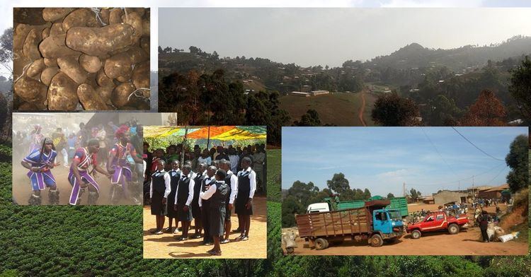
From the then Fem Leteh, Leteh people migrated into the hinterlands and settled at Mbamuock (the residence of Mmuock), also known as Ndzem-Nko'olaq (the rear of Nko'olaq). In the late 70s and early 80s, Leteh people starting migrating from the forest region around Mba-mmuock, to the grassland areas up in the hills at about 2400m above sea level. This resulted from the need to cultivate market garden crops such as potato, garlic and carrots.
Origin of the name
The name Leteh comes from the Mmuock verb lètǽ'lé (IPA: [lətɛʔlə]) meaning: to be not quite agreed upon, to be not quite set. They were so-named because Nkemtang's faction never could agree on any strategy before setting out, and tended to improvise as they went along.
Geography
The relief of Mmuock-Leteh is irregular. The village lies on the summit of the Bamboutous Mountain ranges: The Maleta Plateau is at 2740m above sea level, and is the third highest point on the Western Cameroon Highlands. The relief is very accidented in some places characterised by mountain peaks—each of which is called Ntǿ (IPA: [ntɯ]) in Mmuock language—, steep rolling and pyramidal hills separated by very incised river valleys and ravines.
Mmuock-Leteh occupies part of the western half of the semi-circular caldera that attracts several tourists annually. The village is further defined by a concentric alignment of necks and domes known locally as Mntǿ (peaks). Examples of such peaks include Ntø Maleta (2740m), Ntø Mangua (2710m), Ntø Tiahchia, etc.
Mmuock-Leteh has a tropical mountainous climate of the sub-equatorial type. The accidented nature of the relief has greatly influenced this climate which is characterised by a long rainy season (mid-March to mid-November) and a shorter dry season (mid-November to mid-March). The monthly rainfall ranges between 35mm in January and 605mm in August, August being the wettest month. The temperature varies between 8 and 28 °C: In altitudes above 1800m, night temperatures fall as low as 8 °C during the rainy season.
The soils are volcanic, fertile and rich for agricultural production. (This has led to Mmuock-Leteh farmers winning prizes at the national agro-pastoral shows in Cameroon: in potatoes, carrots and other vegetables). The soil comprises a vegetal material at the summit (35 cm), followed by a humified horizon of 35 to 40 cm, a tertiary horizon and a clayey horizon. These soils have been largely altered and impoverished by erosion and landslides, leading to the loss of much of its organic materials. The 2003 landslides led to destruction of crops, livestock and infrastructure.
The village is covered by a herbaceous Savannah grassland dominated by plants (Poacées and Cyperacées), eucalyptus saligna trees and gallery forest in the lowland areas. Some of the grass species found here, include Cloris sp, Cypérus haspan, Paspalum polystachion, and Axonopus compressus. The forest areas are covered by trees such as pronus aficana, raffia palm, and kolanut trees. Until the early sixties, the lower forest zone harboured several birds and animal species. These included monkeys, chimpanzees, porcupines, squirrels, deers, etc. Extensive poaching has, however, led to the eradication of these animals.
Culture
Mmuock people generally have the same culture. Being of the Bamilike ethnic group, they have a very similar culture to the bordering communities of Bangang, Bafou and Fongo-Tongo, all in the West Region of Cameroon.
Religious beliefs
Although Christianity has been adopted in recent times, Leteh people still adhere to beliefs and practices of traditional religion. At the founding of the village, several shrines were created and dedicated to each of the primary gods of the village. Prominent families typically have a shrine dedicated to the gods of the family; such shrines are usually located at the entrance into the family compound.
The dominant Christian denomination is the Catholic church which displaced the Presbyterian church. Two reasons led to the prominence of the Catholic church. While the lone primary school in the village (P.S. Fotang) was taken over by the government, Catholic School Leteh was created. Secondly, the Presbyterian Church did not have a committed presence in the village. The establishment of St Anthony's Catholic Church and regular visits from priests, caused more and more people to attend the catholic mass. The Divine Mercy Quasi-Parish was created in 2013 with permanent priests.
Rituals for the dead
When a person dies, one or more funeral rites may be performed. The kind and number of rites depend on the deceased's age, rank, and gender.
Succession and kinship
Polygamy is the norm in Mmuock Leteh.
Inheritance and succession passes through the male line. A man is expected to choose a successor before dying. After a man's death, his titles and possessions go by default to the male heir, unless the deceased had made a will or specifically assigned certain possessions to other children.
Wives, too, may have successors. However, a wive's successor does not always need to be expressly stated: it is by default her last child, irrespective of the child's gender; she could also have specified a grandchild.
Education
The first primary school in Leteh started in 1946 in Mbamuock. A Presbyterian school, it was at the entrance into the compound of Tatenkœang (IPA: [tatəŋkɨaŋ]), some 200m up from the palace. Mr Enderley, accompanied by his wife Paulina, was the teacher; the first pupils, Chiatiah (Peter) and Sobetamu (Daniel), were his servants. Many promising pupils were sent away to places as far away as Bali, and the school was moribund before another Presbyterian school, called PS Fotang, was opened higher up at Belang Quarter in 1959.
PS Fotang continued until about 1985 when, with the withdrawal of the Presbyterian church from many primary schools, government took control of the school and renamed it GS Fotang. In 1985, a Catholic School, CS Leteh, was created. Located at Ntemndzem, it is, in terms of population, the biggest catholic primary school in the Mamfe diocese. Two additional public primary schools have since been added; these are GS Maleta and GBPS Ntemndzem.
There are three secondary schools in the village, all located at Ntemndzem. They are GSS Mmuock Leteh, GTC Ntemndzem (a public technical college), and the John Paul II College (a catholic school).
Agriculture
The population of Mmuock Leteh engage in agriculture and livestock breeding as their primary occupation. Although the main market crops are Irish potato and carrots, a diverse range of crops are produced, such as leek, cabbages, beetroot, garlic, maize, and beans.