
Population 486 (2011 Census) | OS grid reference SP568841 Sovereign state United Kingdom District Harborough | |
 | ||
Misterton with Walcote is a civil parish in the English county of Leicestershire. The population of the civil parish at the 2011 census was 486.
Map of Misterton with Walcote, UK
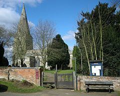
It forms part of the Harborough district. Of its two settlement Walcote is by far the larger, but Misterton has the parish church.
Walcote is on the A4304 road some two miles east if the town of Lutterworth and a mile east of Junction 20 of the M1 motorway. The village now has one public house,The Black horse which has recently re-opened (2017)and the Tavern is now a private dwelling.It has a filling station.
A short circular walk linking Walcote and Misterton can be made by following Brook Street and taking the footpath left which joins a track which passes the Misterton Hall and St. Leonards Church. On reaching the main road, turning left onto a cyclepath by the woods of Misterton Park brings you back to Walcote.