
Mouth elevation 0 | Country Canada | |
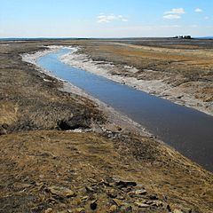 | ||
The Missaguash River is a small Canadian river that forms the southern portion of the inter-provincial boundary between Nova Scotia and New Brunswick on the Isthmus of Chignecto. It had historic significance in the 18th century as the de facto border between French (to the west) and English-controlled territories.
Contents
Map of Missaguash River, Westmorland, NB, Canada
History
The river's name is from the Mi'kmaq language, likely meaning "marsh river", in reference to the Tantramar Marshes through which it flows. The river flows south into Cumberland Basin. Its source is in the Missaguash Bog, several kilometres to the north.
About 1672 a small group of Acadians from Port Royal, led by Jacques Bourgeois, formed a settlement on the south bank of the Missaguash near its mouth named Beaubassin. The settlers reclaimed the salt marsh bordering the Missaquash for cultivation by constructing dykes to keep out the sea.
This village grew until 1750. The French priest Jean-Louis Le Loutre led Mi'kmaq warriors to burn down the village to force the Acadians to relocate to French-held territory north of the Missaquash. He wanted to bring French settlers together in a time of increasing national tensions with Great Britain. In the fall of 1750 the English army under Major Charles Lawrence established Fort Lawrence on the site of the burned village.