
 | ||
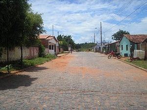
Miravânia is a municipality in the north of the state of Minas Gerais in Brazil. As of 2007 the population was 4,708 in an area of 603 km².
Map of Mirav%C3%A2nia - State of Minas Gerais, Brazil
Miravânia is located on the left bank of the São Francisco River. It is connected by dirt road to São João das Missões by paved BR-135. The distance is 112 km. Neighboring municipalities are: Montalvânia, Manga, Cônego Marinho, and São João das Missões.
The economy is based on agriculture with emphasis on cattle raising. There were 10,000 head in 2006. The main agricultural crops were bananas, rice, corn, and manioc. The GDP was R$12,247,000 in 2005.
This municipality is extremely isolated from major population centers and suffers from drought and poor soils. It is one of the poorest in the state and in the country. Like many impoverished districts it fought for municipal autonomy to apply for government assistance programs.
(For the complete list see Frigoletto)