Rahul Sharma (Editor)

Manga, Minas Gerais

Updated on
Edit
Like
Comment
Share on FacebookTweet on TwitterShare on LinkedInShare on Reddit
Area
  
1,968 km²

Manga, Minas Gerais mangamgnocomunidadesnetimagenslogotipojpg

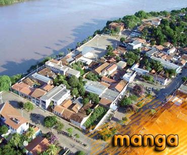
Manga is a municipality in the north of the state of Minas Gerais in Brazil. As of 2007 the population was 20,903 in an area of 1,968 km².

Map of Manga - State of Minas Gerais, Brazil

  • The elevation of the municipal seat is 445 meters.
  • It became a municipality in 1997
  • The postal code (CEP) is 39467-000
  • Statistical microregion: Januária
  • Manga is located on the left bank of the São Francisco River. It is connected to Januária by paved BR-135. The distance is 112 km. Neighboring municipalities are: Matias Cardoso, Montalvânia, Miravânia, Juvenília, and São João das Missões. The distance to the state capital is 720 km.

    The economy is based on agriculture with emphasis on cattle raising. There were 54,000 head in 2006. The main agricultural crops were bananas, lemons, mangoes, rice, corn, manioc, sorghum, sugarcane, and mamona--castor oil plant. The GDP was R$76,786,000 in 2005.

    This municipality is extremely isolated from major population centers and suffers from drought and poor soils. It is one of the poorest in the state and in the country.

  • Municipal Human Development Index: .603 (2000)
  • State ranking: 829 out of 853 municipalities as of 2000
  • National ranking: 4,603 out of 5,138 municipalities as of 2000
  • (For the complete list see Frigoletto)

  • Illiteracy rate: 28.13% (older than 16)--the rate for the state was 11.96% (2000)
  • Infant mortality rate: 34.48--the rate for the state was 17.40 (2000)
  • Urbanization rate: 63%--the rate for the state was 80% (2000)
  • Urban area connected to sewers: 0.70%--the state was 81.39% (2000)
  • Urban area with garbage collection: 71.56%--the state was 91.37 (2000)
  • References

    Manga, Minas Gerais Wikipedia