
Country United States Time zone EST (UTC-5) Zip code 28227 Local time Monday 12:12 PM | Elevation 780 ft (238 m) Area code(s) 704, 980 Population 24,543 (2013) | |
 | ||
Weather 6°C, Wind NE at 16 km/h, 50% Humidity Neighborhoods Wyndemere Crossing, Wilgrove, Wilson Wood, Apple Creek | ||
Country living in the heart of mint hill north carolina
Mint Hill is a suburban town in southeastern Mecklenburg and northwestern Union counties in the U.S. state of North Carolina, it is a major suburb on the outskirts of Charlotte and near the Cabarrus County line. The population was 23,341 at the 2010 census.
Contents
- Country living in the heart of mint hill north carolina
- Map of Mint Hill NC USA
- Geography
- Demographics
- Schools and libraries
- References
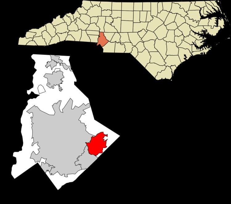
Map of Mint Hill, NC, USA
Geography
Mint Hill is located at 35°10′49″N 80°39′52″W.
According to the United States Census Bureau the town has a total area of 21.3 square miles (55 km2), of which 21.2 square miles (55 km2) is land, and 0.04 square miles (0.10 km2) of it (0.19%) is water.
Demographics
As of the census of 2000, there were 14,922 people, 5,581 households, and 4,431 families residing in the town. The population density was 702.9 people per square mile (271.4/km2). There were 5,763 housing units at an average density of 271.5 per square mile (104.8/km2). The racial makeup of the town was 78.42% White, 12.34% African American, 0.61% Native American, 2.53% Asian, 0.03% Pacific Islander, 4.08% from other races, and 1.99% from two or more races. Hispanic or Latino of any race were 8.29% of the population.
There were 5,581 households out of which 33.9% had children under the age of 18 living with them, 68.9% were married couples living together, 7.4% had a female householder with no husband present, and 20.6% were non-families. 16.4% of all households were made up of individuals and 5.2% had someone living alone who was 65 years of age or older. The average household size was 2.67 and the average family size was 2.98.
In the town, the population was spread out with 24.3% under the age of 18, 7.1% from 18 to 24, 28.5% from 25 to 44, 29.8% from 45 to 64, and 10.3% who were 65 years of age or older. The median age was 39 years. For every 100 females there were 98.1 males. For every 100 females age 18 and over, there were 95.8 males.
The median income for a household in the town was $60,822, and the median income for a family was $67,055. Males had a median income of $45,368 versus $30,467 for females. The per capita income for the town was $26,487. About 2.9% of families and 4.8% of the population were below the poverty line, including 4.9% of those under age 18 and 11.4% of those age 65 or over.
Schools and libraries
The children of Mint Hill, NC attend Charlotte-Mecklenburg Schools. Elementary schools include Clear Creek Elementary, Bain Elementary, Crown Point Elementary, and Lebanon Road Elementary. Middle schools include Northeast Middle, and Mint Hill Middle. High school students attend either Independence High School or Butler High School. Mint Hill is also home to the Queens Grant Charter schools.
Mint Hill is served by a branch of the Public Library of Charlotte and Mecklenburg County.