Rahul Sharma (Editor)

Minnesota's congressional districts

Updated on
Edit
Like
Comment
Share on FacebookTweet on TwitterShare on LinkedInShare on Reddit
Minnesota's congressional districts

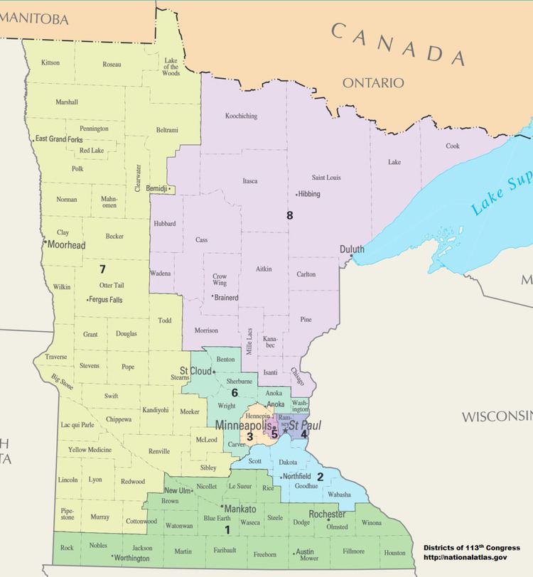
Minnesota is currently divided into 8 congressional districts, each represented by a member of the United States House of Representatives. After the 2010 Census, the number of Minnesota's seats remained unchanged.

Contents

Minnesota statutes do not require candidates for the United States House of Representatives to reside in the district in which they run for office, but candidates must be inhabitants of the state at the time of the election.

Current districts and representatives

List of members of the Minnesotan United States House delegation, their terms, their district boundaries, and the districts' political ratings according to the CPVI. The delegation has a total of 8 members, including 5 Democrats, and 3 Republicans.

Districts

Districts were re-drawn in 2012. The 2010 elections determined the officials for the 2011–2013 term using 2002 districts, while the 2012 elections used the new districts. The 2002–2012 districts are described below:

  • Minnesota's 1st congressional district extends across southern Minnesota from the border with South Dakota to the border of Wisconsin.
  • Minnesota's 2nd congressional district spans the width of the entire southern metro area and contains Dakota, Carver, Scott, Le Sueur, Goodhue and Rice Counties.
  • Minnesota's 3rd congressional district encompasses the suburbs of Hennepin County to the north, west, and south of Minneapolis.
  • Minnesota's 4th congressional district covers most of Ramsey County including all of St. Paul and several St. Paul suburbs and part of Dakota.
  • Minnesota's 5th congressional district covers eastern Hennepin County, including the entire city of Minneapolis, along with parts of Anoka and Ramsey counties
  • Minnesota's 6th congressional district includes most or all of Benton, Sherburne, Stearns, Wright, Anoka, and Washington counties.
  • Minnesota's 7th congressional district covers almost all of the western side of Minnesota from the Canada–US border down to Lincoln County and is the largest district in the state.
  • Minnesota's 8th congressional district covers the northeastern part of Minnesota and includes Duluth, Brainerd, and the Mesabi Range.
  • Minnesota's two U.S. Senators are elected at large.
  • Congressional districts are also used to ensure regional representation on other government bodies within the state. The following entities are required by state statute to have at least one member from each congressional district:

  • The Minnesota Court of Appeals (based on a judge's place of residence for a minimum of one year upon initial appointment or election).
  • The Board of Regents of the University of Minnesota.
  • The Minnesota State Colleges and Universities System Board of Trustees.
  • The state Board of Invention.
  • Historical and present district boundaries

    Table of United States congressional district boundary maps in the State of Minnesota, presented chronologically. All redistricting events that took place in Minnesota between 1973 and 2013 are shown.

    Obsolete districts

    Minnesota currently has eight congressional districts. There were 9th and 10th districts but they were eliminated in 1963 and 1933 respectively. Redistricting is done every 10 years to reflect population shifts within the United States.

  • 9th district: 1903–1933, 1935–1963 (obsolete since the 1960 census)
  • 10th district: 1915–1933 (obsolete since the 1930 census)
  • References

    Minnesota's congressional districts Wikipedia