
Primary outflows Kura River Max. length 70 km (43 mi) Area 605 km² Width 18 km Inflow source Kura Outflow location Kura | Primary inflows Basin countries Azerbaijan Max. width 18 km (11 mi) Length 70 km Mean depth 26 m Year built 1953 | |
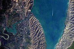 | ||
The Mingachevir reservoir (Azerbaijani: Mingəçevir su anbarı) is a large reservoir in northwestern Azerbaijan. It is the largest reservoir in the Caucasus.
Contents
Map of Mingachevir reservoir, Mingecevir, Azerbaijan
Overview
The reservoir was built on a section of Kura River flowing through Mount Bozdağ in 1953. The filling capacity of the reservoir is 83 m (272 ft) whereas the volume is 15.73 km³. It has been filled to its maximum levels in 1959, 1963, 1968, 1973, 1975, 1976, 1978, 1988 and 2010. The length is 70 km (43 mi) and width is 18 km (11 mi). Maximum depth is 75 m (246 ft), average depth - 26 m (85 ft). The length along the shoreline is 247 km (153 mi), the overall area is 605 km2 (234 sq mi). The largest hydroelectric power station of Azerbaijan is located on the reservoir. Mingachevir Hydro Power Plant has an installed electric capacity of 401.6 megawatts. The length of the hydroelectric dam is 1,550 m (5,090 ft), its width is 16 m (52 ft) and height is 80 m (260 ft).
The reservoir supplies water to Upper Karabakh and Upper Shirvan channels. It is also a source for fishing, water supplies and irrigation.
As a possible military target
Within the context of the Nagorno-Karabakh conflict, scholars and politicians have speculated the possibility of the Mingachevir reservoir being used as a military target by Armenian forces in case of another war. Russian ethnographer Sergey Arutyunov stated in a 2010 interview:
I will not disclose a military secret—this has been openly admitted in Armenia's general staff—that Armenian or NKR artillery batteries, stationed at the top of Karabakh mountains, are 40 kilometers away from the Mingachevir reservoir. One strike and central Azerbaijan will turn into a sea.
In the aftermath of the 2014 Armenian–Azerbaijani clashes, Armenia's Defense Minister Seyran Ohanyan stated at the government session on August 7 that the Troops of the Civil Defense of the Azerbaijani Ministry of Emergency Situations have recently been mainly protecting the Mingachevir Hydro Power Plant fearing an attack by the Armenian forces. In response, the Azerbaijani Defense Ministry issued a statement the next day which said that the "The Armenian people should know that the response to any sabotage attempts against Mingachevir Hydro Power Plant from the Armenian side will be more miserable" and cautioned that Azerbaijan had the capability to raze Yerevan, Armenia's capital.
Telman Zeynalov, president of the National Center of Environmental Forecasting, said in an interview that the entire area from Arran (i.e. the great triangle of land, lowland in the east but rising to mountains in the west, formed by the junction of the rivers Kura and Aras) to Baku, the Azerbaijani capital, would be flooded if Mingachevir dam was destroyed. In his words, it would lead to a "large-scale environmental disaster." Zeynalov added that the Armenian side should be cautious because the flooding "would affect both sides" and most of Armenian-controlled Karabakh would also be flooded. The latter claim was rejected by Armenian analyst Hrant Melik-Shahnazaryan who stated that the waters of the Mingachevir reservoir cannot possibly reach the highlands of Karabakh.