
 | ||
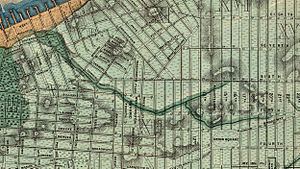
Showing minetta creek
Minetta Creek (sometimes called Minetta Brook, Minetta Stream, Minetta Water, Minetta Waters, or by its Dutch name, Bestevaer's Killetje, before the American Revolutionary War), was a stream that was among the largest natural watercourses in Manhattan, New York City. Nearly two miles long, it began from two tributaries, the main one having its source near what is now Fifth Avenue and Twenty-first Street, and a secondary one that had its source at Sixth Avenue and Sixteenth Street. The streams flowed southward and joined between Eleventh and Twelfth Streets between Fifth and Sixth Avenues. From there it flowed southward across what is today Washington Square Park, it then crossed southwest, traversing what is today its namesake street – Minetta Street – and then Downing Street, eventually discharging into the Hudson River near what is currently Charlton Street. The creek was filled in by the mid-nineteenth century, although it persisted as an underground stream through the twentieth century. Debate continues on whether the creek still exists.
Contents
- Showing minetta creek
- Origins of name
- Colonial days
- Covering of the creek
- Encounters with the creek underground
- References
Origins of name
A plaque affixed to the building at Two Fifth Avenue provides one derivation of the name and reads as follows:
A brook winds its erratic way beneath this site
The Indians called it Manette or Devil's Water To the Dutch settlers it was Bestevaer's Killetje or Grandfather's Little Creek For the past two centuries familiar to this neighborhood as Minetta Brook
Another theory is that the name is an anglicization of the Dutch root "min" or "minuut" (English: little) and suffix "-tje" to produce "Minnetje" or "The little one" to distinguish it from the Groot Kill, a large creek that was a mile away.
Colonial days
The creek, whose course formed a well-defined channel, was known for its abundance of fish, in particular trout. Pickerel, bass, and pike were among the species fished in it. "All manner of wild fowl" including ducks and geese could be found in the creek. In fact the filling-in had preceded real-estate speculators' infill, according to the British Headquarters Map of c 1782–83, when the British carried out extensive defenses of the city: "they dammed Minetta Water to create a lake in what is now the West Village"
Bestevaer's Killetje formed a convenient landmark designation for surveyors. Murray Hoffman's Treatise Upon the Estate and Rights of the Corporation of the City of New York, as Proprietors reprints numerous historical documents from the seventeenth and eighteenth centuries, a number of which mention Minetta Creek. Most of these pre-nineteenth century documents refer to the creek by its Dutch name, Bestavaer's Killtjie (or, in a more probable spelling, Bestevaer's Killetje). One of the most significant of pre-American Revolutionary War documents consolidating ownership of land in Manhattan was the Montgomerie Charter, named after governor John Montgomerie, dated January 15, 1730 and ratified by the Colonial Legislature in 1732. It stated in part:
... [A]ll that space of ground and soil of the Hudson river, now lying and being under the water of the same river, to begin at a certain place near high water mark at the south end of a piece of upland, which lies between the said river and a piece of meadow ground or marsh, being the first piece of meadow ground or marsh near Hudson river to the southward of Greenwich, and from whence the above named run of water called Bestaver's Killetjie or rivulet runs into Hudson's river, from which place of beginning, to extend or run to the south side of the street which runs from the parade before our fort in New York to the Hudson's river, south eighteen degrees thirty minutes west, on a straight line; the distance being one hundred and twenty-five chains [i.e. 8,250 feet (2,510 m) or 1.417 miles (2.280 km)], from which line to run a perpendicular breadth of, and to comprehend four hundred feet [120 metres] from low water mark into Hudson's river.
The Land Ordinance of 1796 – a U.S. federal cadastral survey done for purposes of taxation, also reprinted by Hoffman – laid out the line of West Street, which had been built over landfill, and noting three geographical points. The first was a point 150 feet (46 m) north of Greenwich Street "from the center of the arch or bridge over Bestaver's Killtjie." Hoffman added a note: "Bestaver's Killtjie was afterward known as the Minetta Brook, and crossed Greenwich street in the vicinity of Charlton Street." He concludes his note by stating that this geographic point is represented in an 1807 map made by Charles Loss.
A swamp area existed in what is now Washington Square Park, fed by the waters of Minetta Creek. The creek served as a boundary between a potter's field which was established on April 7, 1797 and was in operation until May 25, 1825, on its eastern bank, and private property to its west.
The southernmost part of the creek's course was the estate known as Richmond Hill, originally created by Abraham Mortier in the late 1760s. In 1794 he leased it to Aaron Burr, who altered the course of the creek to form "Burr's Pond" at the foot of his estate.
Covering of the creek
Charles Haynes Haswell recalled in 1896 that in 1816 Minetta Stream "was fully apparent; and as it was and is of considerable volume, it has been [a] very important and expensive factor in the construction of the foundations along its line, from its main source, near the site of the Union Club, to its discharge in the North [i.e. Hudson] River." "In 1820 there still was a small colony of muskrats, bordering this creek," Issachar Cozzens recalled in 1843. "The brook passed along the lower end of Potter's Field, and formed a large pond called Bollus's Pond, where Downing Street now is; the low swampy grounds that were filled up caused this pond, which lay a little north-west of Richmond Hill."
The covering in of Minetta Stream began in 1820, when the common council appointed James Wallace to build a Minetta sewer. Joan H. Geismar, an urban archeologist who wrote an archeological assessment of Washington Square Park in 2005, hypothesized that the purpose of this sewer was in part to function as a drain directing water away from the potter's field. Geismar surmised that the building of the sewer was not enough for the creek to avoid the cemetery because in 1823, the common council directed Thomas Cummings to deepen the riverbed of Minetta Creek. Due to the opening of Fifth Avenue, on December 10, 1824, the Council directed that Minetta Creek be culverted from its location at Fourth Street (now Washington Square South) to Sixth Street (now Washington Square North). With the closing of the potter's field on May 25, 1825, the council chose to transform the area into a military parade ground, which eventually became Washington Square Park. By autumn 1828, the creek was diverted to the Hudson River through a wooden sewer. By 1849, the Richmond Hill estate near the southern end of the stream had been demolished, with row houses taking its place, indicating that water no longer flowed through the area. The residential brownstone residence at 45 West Twelfth Street was built in 1846. The odd shape of its eastern wall, slightly overlapping its neighbor at 43 West Twelfth Street (erected in 1861), is due to being built on the bank of Minetta Creek.
With increasing numbers of immigrants moving to the area during the latter half of the nineteenth century, several doctors were appointed by the New York State Legislature to investigate housing conditions in tenements, and they spent many days interrogating various residents. On Oct. 27, 1884 they interrogated John F. Attridge, a real estate agent, on living conditions in various kinds of housing in lower Manhattan. At one point Doctor S. Oakley Vanderpoel raised the subject of whether houses built over filled-in ground had proper drainage. To this Attridge responded: "I lived for fifteen years over Minetta Brook, and the people always considered it the most unhealthy place in New York, but there was nobody sick."
In 1892, the New York Times reported the flooding of the cellar of Solomon Sayles, a merchant whose store was located at 126 Sixth Avenue, between Tenth and Eleventh Streets. This incident provided the Times's reporter an opportunity to speak with Egbert Ludovicus Viele, who had designed the Topographical & Sanitary Map of Manhattan published in 1865. Viele had first investigated the creek in 1860, using a British survey made at the time of the Revolutionary War. Viele explained that the creek was a source of water prior to construction of the Croton Distributing Reservoir. Once the reservoir had been completed in 1842, the creek was no longer needed as a water source, and it became a dumping ground. When Viele once gave a talk on the creek, an elderly physician in the audience recalled cases of intermittent fever due to the creek. Viele was quoted as saying "I have no doubt that the water in Mr. Sayles's cellar comes from the sources of Minetta Creek." He went on to describe the source of Minetta Creek as a perennial spring. Such springs are as natural as the island's rock formations and cannot be dammed, Viele concluded. The 1892 article recommended better drainage for Manhattan's subterranean water sources.
In his 1894 book, In Old New York, Thomas A. Janvier wrote: "Although Manetta Creek no longer is visible on the surface, it still flows in diminished volume through its ancient channel—as those living near or over it sometimes know to their cost." Janvier described the creek's path and warned that no buildings could be built on or near it without extensive reinforcements to their foundations. In addition to Sayles's store, he mentioned the recent floodings of the Lincoln Building at the southwest corner of Union Square, the building at the northeast corner of 19th Street and Fifth Avenue, and 66 Fifth Avenue.
In 1897, George Everett Hill and George E. Waring, Jr. wrote: "Although Minetta Brook has been lost to sight for many years, we have abundant evidence that it still exists. Deep excavations near its course are almost invariably flooded by its waters, and heavy buildings over or beside it require elaborate foundations of piling."
Encounters with the creek underground
Encounters with Minetta Creek in the twentieth century were based on construction projects that unexpectedly encountered its water underground:
Bloggers who live near where the creek ran claim that it still exists, based on evidence of flooding in basements and cellars. Will Hunt, searching in 2011, could not find any evidence of subterranean water.