
Status public walkway | Country United States of America | |
 | ||
Location Cambridge, Massachusetts Boston, Massachusetts Public transit access Community College (MBTA station) Similar Teays River, Bian River (China), Helicon (river) | ||
Millers River was a river in Middlesex County, Massachusetts. It has since mostly been obscured by landfill, and made land (land created by filling of waterways). It once formed part of the eastern border between the cities of Cambridge and Somerville.
Contents
- Map of Millers River East Cambridge MA USA
- History
- Issues regarding construction by the Central Artery Tunnel Project
- Pedestrian access and public artwork
- Future restoration of Millers River
- References
Map of Millers River, East Cambridge, MA, USA
History
Millers River flowed into the Charles River, providing water transport to commercial and industrial sites along its shores beginning in the early Colonial period. It was previously called Willis Creek and is labeled as such on the 1777 Pelham Map, among others. In the late 19th century, Millers River was used as a dumping place for wastes from abattoirs and slaughterhouses. The stench and health problems related to this use resulted in some of the first public health based anti-pollution environmental laws in Massachusetts and provided precedent for early environmental protection laws throughout the United States. As a result of these issues Chapter 91 of the Massachusetts General Laws was established in 1866 to regulate uses of tidal waterways and is a powerful tool to protect the public welfare in relationship to filled and flowing tidelands today. The inaccessible and degraded industrial landscape around Millers River and along the lower Charles River basin became known during the late 19th century and 20th century as, "the Lost Half-Mile".
Issues regarding construction by the Central Artery Tunnel Project
There is a small surviving section of Millers River around the Zakim Bridge development. This several hundred yard-long section of river became the source of many contentious environmental issues during planning for the Big Dig highway project. The Charles River Watershed Association and The Conservation Law Foundation led efforts to protect Millers River and open it for public access. Permit requirements prevented the remaining section of the river from being filled, and Chapter 91 permits mandated pedestrian access to the previously inaccessible section of the Northern bank of the Charles River.
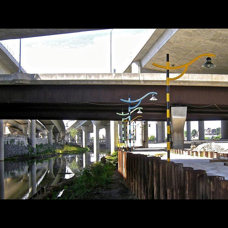
Pedestrian access and public artwork
A pedestrian walkway with playfully designed light poles, interpretive historical panels, and bordered by re-introduced wetland vegetation provides access along the remaining section of Millers River between the Charles River and Rutherford Avenue in Charlestown, Massachusetts. A linear Public Art project, Millers River Littoral Way, provides a series of artworks, graphics, lighting and sculptures that include etchings of historic pre-landfill harbor depths and a memorial to former potato sheds, that lead pedestrians through the grid of structural piers that support Interstate Highway I-93 above. The mouth of Millers River, closed off by railroad tracks and wharves since the 1830s, was opened to the Charles River as a part of Central Artery construction. Where Millers River meets the North bank of the Charles River a new park landscape (completed 2012) provides pedestrian and bicycle access under the Zakim Bridge. Landscape features built from reclaimed granite seawall blocks and a light-based public artwork, 5 Beacons for the Lost Half Mile, guide visitors from North Point Park to Paul Revere Park.
Future restoration of Millers River
Several now-buried sections of the Millers River watershed have been identified by the Charles River Watershed Association and others as locations to develop in order to improve local water quality and increase natural rainwater storage. Options to achieve this include opening culverted drainage, providing surface water recharge infiltration swales, and exploring the "daylighting" (opening up) of portions of the now-filled Miller's River.