
- summer (DST) CEST (UTC+2) Area 15.3 km² | Elevation 165 m Local time Wednesday 8:16 AM | |
 | ||
Weather 10°C, Wind N at 23 km/h, 83% Humidity Points of interest Mikulčice Archaeopark, Vinařství Marada, Skařiny, Vinařství Maláník‑Osička - Mikulčice | ||
Mikulčice ( [ˈmi.kul.tʃi.tsɛ]) is a municipality (obec) in the Czech Republic, situated 7 km south of Hodonín, nearby the Slovak border. It extends for 1,530 ha, comprising 1,955 inhabitants in 623 homes, and a biospheric reserve, containing beavers and storks. The local economy is predominantly based on agriculture and tourism.
Contents
Map of 696 19 Mikul%C4%8Dice, Czechia
History
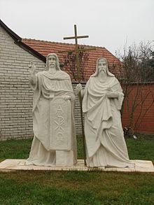
From the sixth until the tenth century, a Slavic fortified settlement existed 3 km away from the modern village. The settlement was one of the main centres of the Great Moravian Empire, plausibly its capital city. Excavations, led by Josef Poulík, unearthed the remnants of twelve churches, a palace, and more than 2,500 graves (three containing African skeletons) (including a horse burial). The only still-standing church safely dated to the Great Moravian period is found in the nearby Slovak village of Kopčany. The excavation complex is nationally recognised as the Mikulčice-Valy or Mikulčice Archaeopark heritage site.
The oldest written reference to the village itself dates to 1131, when the village was referred to as Miculcici in Medieval Latin. Both the Czech Mikulčice and the Latin Miculcici are nouns which exist only in the plural form, like the Netherlands. Mikulčice meaning simply "the people of Mikul (dialectal form of Nicholas)".